Hebei geodata
Hebei (Beijing) is a seat of a fourth-order administrative division; located in China in Asia/Shanghai (GMT+8) time zone. In our database, there are 1268 cities with bigger population. Compared to other cities in China, 85.7% of cities are located further ↓South; 59.6% of cities are located further ←West and 54.8% of cities have higher elevation than Hebei. Note1


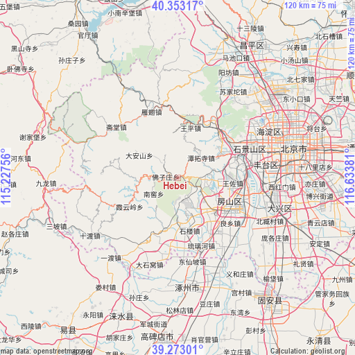
Hebei GPS coordinates[2]
39° 48' 54.756" North, 115° 55' 50.448" East
| Map corner | latitude | longitude |
|---|---|---|
| Upper-left | 40.35317°, | 115.22756° |
| Center: | 39.81521°, | 115.93068° |
| Lower-right: | 39.27301°, | 116.63381° |
| Map W x H: | 120.1×120.1 km | = 74.6×74.6mi |
| max Lat: | 53.31946° ⇑14.3% North |
| Hebei: | 39.81521° |
| min Lat: | ⇓85.7% South 18.22056° |
| min Long | Hebei | max Long |
| 75.07348° | 115.93068° | 134.28917° |
| W 59.6%⇐ | ⇒40.4% E |
Elevation
Elevation of Hebei is 133 m = 436 ft, and this is 351.8 m = 1154 ft below average elevation for this country.
| Max E: |
5622 m = 18445 ft | 54.8% |
| Avg. | 484.8 m = 1591 ft | |
| Hebei | 133 m = 436 ft | |
Min E: |
-3 m = -10 ft | 45.2% |
See also: China elevation on elevation.city.
Geographical zone
Hebei is located in North temperate zone (between Tropic of Cancer and the Arctic Circle). Distance of this Northern Tropic circle is 1821.1 km =1131.6 mi to South.| Distance of | km | miles | from Hebei |
|---|---|---|---|
| North Pole | 5580 | 3467.3 | to North |
| Arctic Circle | 2974.1 | 1848 | to North |
| Tropic Cancer | 1821.1 | 1131.6 | to South |
| Equator | 4427 | 2750.8 | to South |


Nearby cities:
15 places around Hebei: (largest is in red/bold)
• Dayu
19.6 km =12.2 mi,  46°
46°
• Da’anshan
15.2 km =9.4 mi,  301°
301°
• Fangshan
15.3 km =9.5 mi,  158°
158°
• Gongchen
20.2 km =12.6 mi,  118°
118°
• Liangxiang
19.4 km =12.1 mi, 117°
• Mentougou
19.5 km =12.1 mi, 45°
• Miaofengshan
20.3 km =12.6 mi,  29°
29°
• Nanjiao
9.6 km =6 mi,  234°
234°
• Qinglonghu
10 km =6.2 mi, 117°
• Tanzhesi
10.5 km =6.5 mi, 52°
• Wangping
17.4 km =10.8 mi,  14°
14°
• Wangzuo
19.3 km =12 mi,  92°
92°
• Xiangyang
8.4 km =5.2 mi, 164°
• Xiayunling
19.5 km =12.1 mi,  238°
238°
• Zhoukoudian
14.6 km =9.1 mi,  178°
178°
Sources, notices
• [Note1] Compared only with cities in China existing in our database
• [Src1] Map data: © OpenStreetMap contributors (CC-BY-SA)
• [Src2] Other city data from geonames.org with taken over terms of usage.
• [Src3] Geographical zone / Annual Mean Temperature by Robert A. Rohde @ Wikipedia
