Fangli geodata
Fangli (Shaanxi) is a seat of a fourth-order administrative division; located in China in Asia/Shanghai (GMT+8) time zone. In our database, there are 1268 cities with bigger population. Compared to other cities in China, 74.4% of cities are located further ↓South; 77.5% of cities are located further →East and 84.1% of cities have lower elevation than Fangli. Note1


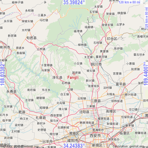
Fangli GPS coordinates[2]
34° 49' 23.016" North, 108° 44' 12.984" East
| Map corner | latitude | longitude |
|---|---|---|
| Upper-left | 35.39824°, | 108.03382° |
| Center: | 34.82306°, | 108.73694° |
| Lower-right: | 34.24383°, | 109.44007° |
| Map W x H: | 128.4×128.4 km | = 79.8×79.8mi |
| max Lat: | 53.31946° ⇑25.6% North |
| Fangli: | 34.82306° |
| min Lat: | ⇓74.4% South 18.22056° |
| min Long | Fangli | max Long |
| 75.07348° | 108.73694° | 134.28917° |
| W 22.5%⇐ | ⇒77.5% E |
Elevation
Elevation of Fangli is 919 m = 3015 ft, and this is 434.2 m = 1425 ft above average elevation for this country.
| Max E: |
5622 m = 18445 ft | 15.9% |
| Fangli | 919 m 3015 ft | |
| Avg. | 484.8 m = 1591 ft | |
Min E: |
-3 m = -10 ft | 84.1% |
See also: China elevation on elevation.city.
Geographical zone
Fangli is located in North temperate zone (between Tropic of Cancer and the Arctic Circle). Distance of this Northern Tropic circle is 1266 km =786.7 mi to South.| Distance of | km | miles | from Fangli |
|---|---|---|---|
| North Pole | 6135.1 | 3812.2 | to North |
| Arctic Circle | 3529.2 | 2192.9 | to North |
| Tropic Cancer | 1266 | 786.7 | to South |
| Equator | 3872 | 2405.9 | to South |


Nearby cities:
15 places around Fangli: (largest is in red/bold)
• Baiwang
18.5 km =11.5 mi,  205°
205°
• Chunhua
15 km =9.3 mi,  259°
259°
• Cuo’e
16 km =9.9 mi,  125°
125°
• Dadian
12.8 km =8 mi,  245°
245°
• Dongwu
19.2 km =11.9 mi, 262°
• Guanzhuang
19 km =11.8 mi,  38°
38°
• Guxian
2.5 km =1.6 mi,  46°
46°
• Kouzhen
13.2 km =8.2 mi,  195°
195°
• Ma’e
17.6 km =10.9 mi,  89°
89°
• Potou
14.8 km =9.2 mi,  77°
77°
• Qinhe
17 km =10.6 mi,  309°
309°
• Shiqiao
10.1 km =6.3 mi,  224°
224°
• Tiewang
18.3 km =11.4 mi,  304°
304°
• Xiaoqiu
10.1 km =6.3 mi,  18°
18°
• Xinxing
14.5 km =9 mi,  111°
111°
Sources, notices
• [Note1] Compared only with cities in China existing in our database
• [Src1] Map data: © OpenStreetMap contributors (CC-BY-SA)
• [Src2] Other city data from geonames.org with taken over terms of usage.
• [Src3] Geographical zone / Annual Mean Temperature by Robert A. Rohde @ Wikipedia
