Xiaoxia geodata
Xiaoxia (Qinghai) is a seat of a fourth-order administrative division; located in China in Asia/Shanghai (GMT+8) time zone. In our database, there are 1268 cities with bigger population. Compared to other cities in China, 78.3% of cities are located further ↓South; 92.9% of cities are located further →East and 95.1% of cities have lower elevation than Xiaoxia. Note1


Xiaoxia GPS coordinates[2]
36° 31' 51.348" North, 101° 58' 2.856" East
| Map corner | latitude | longitude |
|---|---|---|
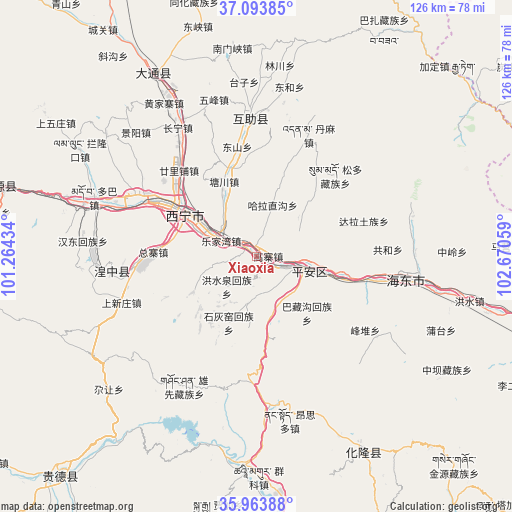
| Upper-left | 37.09385°, | 101.26434° |
| Center: | 36.53093°, | 101.96746° |
| Lower-right: | 35.96388°, | 102.67059° |
| Map W x H: | 125.6×125.6 km | = 78×78mi |
| max Lat: | 53.31946° ⇑21.7% North |
| Xiaoxia: | 36.53093° |
| min Lat: | ⇓78.3% South 18.22056° |
| min Long | Xiaoxia | max Long |
| 75.07348° | 101.96746° | 134.28917° |
| W 7.1%⇐ | ⇒92.9% E |
Elevation
Elevation of Xiaoxia is 2157 m = 7077 ft, and this is 1672.2 m = 5486 ft above average elevation for this country.
| Max E: |
5622 m = 18445 ft | 4.9% |
| Xiaoxia | 2157 m 7077 ft | |
| Avg. | 484.8 m = 1591 ft | |
Min E: |
-3 m = -10 ft | 95.1% |
See also: China elevation on elevation.city.
Geographical zone
Xiaoxia is located in North temperate zone (between Tropic of Cancer and the Arctic Circle). Distance of this Northern Tropic circle is 1455.9 km =904.7 mi to South.| Distance of | km | miles | from Xiaoxia |
|---|---|---|---|
| North Pole | 5945.2 | 3694.2 | to North |
| Arctic Circle | 3339.3 | 2074.9 | to North |
| Tropic Cancer | 1455.9 | 904.7 | to South |
| Equator | 4061.9 | 2523.9 | to South |


Nearby cities:
15 places around Xiaoxia: (largest is in red/bold)
• Ershilipu
27.5 km =17.1 mi,  316°
316°
• Gaozhai
2.2 km =1.4 mi,  49°
49°
• Gucheng
19.4 km =12.1 mi,  172°
172°
• Haizigou
35.3 km =21.9 mi,  303°
303°
• Hongshuiquan
10.6 km =6.6 mi,  225°
225°
• Lushar
36.5 km =22.7 mi,  261°
261°
• Sanhe
12.5 km =7.8 mi,  195°
195°
• Shangxinzhuang
37.9 km =23.5 mi,  249°
249°
• Shihuiyao
18.2 km =11.3 mi,  205°
205°
• Sitai
18.5 km =11.5 mi,  190°
190°
• Tianjiazhai
17.8 km =11.1 mi,  241°
241°
• Weiyuan
35.9 km =22.3 mi,  3°
3°
• Xining
21.5 km =13.4 mi, 299°
• Xishan
29.2 km =18.1 mi,  338°
338°
• Zongzhai
23.2 km =14.4 mi,  269°
269°
Sources, notices
• [Note1] Compared only with cities in China existing in our database
• [Src1] Map data: © OpenStreetMap contributors (CC-BY-SA)
• [Src2] Other city data from geonames.org with taken over terms of usage.
• [Src3] Geographical zone / Annual Mean Temperature by Robert A. Rohde @ Wikipedia
