Gaozhai geodata
Gaozhai (Qinghai) is a seat of a fourth-order administrative division; located in China in Asia/Shanghai (GMT+8) time zone. In our database, there are 1268 cities with bigger population. Compared to other cities in China, 78.3% of cities are located further ↓South; 92.9% of cities are located further →East and 95.2% of cities have lower elevation than Gaozhai. Note1


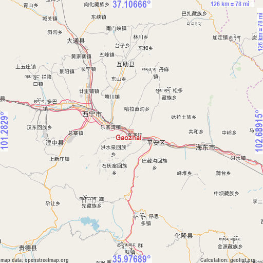
Gaozhai GPS coordinates[2]
36° 32' 37.824" North, 101° 59' 9.672" East
| Map corner | latitude | longitude |
|---|---|---|
| Upper-left | 37.10666°, | 101.2829° |
| Center: | 36.54384°, | 101.98602° |
| Lower-right: | 35.97689°, | 102.68915° |
| Map W x H: | 125.6×125.6 km | = 78×78mi |
| max Lat: | 53.31946° ⇑21.7% North |
| Gaozhai: | 36.54384° |
| min Lat: | ⇓78.3% South 18.22056° |
| min Long | Gaozhai | max Long |
| 75.07348° | 101.98602° | 134.28917° |
| W 7.1%⇐ | ⇒92.9% E |
Elevation
Elevation of Gaozhai is 2197 m = 7208 ft, and this is 1712.2 m = 5617 ft above average elevation for this country.
| Max E: |
5622 m = 18445 ft | 4.8% |
| Gaozhai | 2197 m 7208 ft | |
| Avg. | 484.8 m = 1591 ft | |
Min E: |
-3 m = -10 ft | 95.2% |
See also: China elevation on elevation.city.
Geographical zone
Gaozhai is located in North temperate zone (between Tropic of Cancer and the Arctic Circle). Distance of this Northern Tropic circle is 1457.4 km =905.6 mi to South.| Distance of | km | miles | from Gaozhai |
|---|---|---|---|
| North Pole | 5943.8 | 3693.3 | to North |
| Arctic Circle | 3337.9 | 2074.1 | to North |
| Tropic Cancer | 1457.4 | 905.6 | to South |
| Equator | 4063.3 | 2524.8 | to South |


Nearby cities:
15 places around Gaozhai: (largest is in red/bold)
• Ershilipu
27.7 km =17.2 mi,  311°
311°
• Gucheng
20.7 km =12.9 mi,  177°
177°
• Haizigou
35.9 km =22.3 mi,  300°
300°
• Hongshuiquan
12.8 km =8 mi,  226°
226°
• Lushar
38.4 km =23.9 mi,  260°
260°
• Sanhe
14.4 km =8.9 mi,  200°
200°
• Shihuiyao
20.2 km =12.6 mi,  207°
207°
• Sitai
20.2 km =12.6 mi,  194°
194°
• Tianjiazhai
19.9 km =12.4 mi,  239°
239°
• Weiyuan
34.4 km =21.4 mi,  0°
0°
• Wufeng
38.4 km =23.9 mi,  341°
341°
• Xiaoxia
2.2 km =1.4 mi, 229°
• Xining
22.3 km =13.9 mi,  293°
293°
• Xishan
28.5 km =17.7 mi,  334°
334°
• Zongzhai
24.9 km =15.5 mi,  266°
266°
Sources, notices
• [Note1] Compared only with cities in China existing in our database
• [Src1] Map data: © OpenStreetMap contributors (CC-BY-SA)
• [Src2] Other city data from geonames.org with taken over terms of usage.
• [Src3] Geographical zone / Annual Mean Temperature by Robert A. Rohde @ Wikipedia
