Erkou geodata
Erkou (Jiangxi) is a seat of a fourth-order administrative division; located in China in Asia/Shanghai (GMT+8) time zone. In our database, there are 1268 cities with bigger population. Compared to other cities in China, 74.3% of cities are located further ↑North; 66.7% of cities are located further ←West and 57.1% of cities have higher elevation than Erkou. Note1


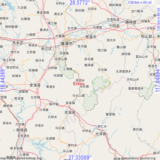
Erkou GPS coordinates[2]
27° 57' 28.548" North, 117° 8' 44.916" East
| Map corner | latitude | longitude |
|---|---|---|
| Upper-left | 28.5772°, | 116.44269° |
| Center: | 27.95793°, | 117.14581° |
| Lower-right: | 27.33509°, | 117.84894° |
| Map W x H: | 138.1×138.1 km | = 85.8×85.8mi |
| max Lat: | 53.31946° ⇑74.3% North |
| Erkou: | 27.95793° |
| min Lat: | ⇓25.7% South 18.22056° |
| min Long | Erkou | max Long |
| 75.07348° | 117.14581° | 134.28917° |
| W 66.7%⇐ | ⇒33.3% E |
Elevation
Elevation of Erkou is 117 m = 384 ft, and this is 367.8 m = 1207 ft below average elevation for this country.
| Max E: |
5622 m = 18445 ft | 57.1% |
| Avg. | 484.8 m = 1591 ft | |
| Erkou | 117 m = 384 ft | |
Min E: |
-3 m = -10 ft | 42.9% |
See also: China elevation on elevation.city.
Geographical zone
Erkou is located in North temperate zone (between Tropic of Cancer and the Arctic Circle). Distance of this Northern Tropic circle is 502.7 km =312.4 mi to South.| Distance of | km | miles | from Erkou |
|---|---|---|---|
| North Pole | 6898.4 | 4286.5 | to North |
| Arctic Circle | 4292.5 | 2667.2 | to North |
| Tropic Cancer | 502.7 | 312.4 | to South |
| Equator | 3108.6 | 1931.6 | to South |


Nearby cities:
15 places around Erkou: (largest is in red/bold)
• Gangkou
32 km =19.9 mi,  36°
36°
• Heyuan
19.4 km =12.1 mi,  282°
282°
• Jintun
20.3 km =12.6 mi,  23°
23°
• Lengshui
6.6 km =4.1 mi,  144°
144°
• Longhushan
24.8 km =15.4 mi,  317°
317°
• Lufang
32.5 km =20.2 mi, 280°
• Luohe
28.2 km =17.5 mi,  6°
6°
• Maquanzhen
35.5 km =22.1 mi,  308°
308°
• Pengwan
15.5 km =9.6 mi,  351°
351°
• Shangqing
14.7 km =9.1 mi, 311°
• Songshi
30.6 km =19 mi,  228°
228°
• Tangwan
15.2 km =9.4 mi,  29°
29°
• Wenfang
21 km =13 mi,  64°
64°
• Yujia
26.9 km =16.7 mi,  333°
333°
• Zhangping
27.3 km =17 mi,  80°
80°
Sources, notices
• [Note1] Compared only with cities in China existing in our database
• [Src1] Map data: © OpenStreetMap contributors (CC-BY-SA)
• [Src2] Other city data from geonames.org with taken over terms of usage.
• [Src3] Geographical zone / Annual Mean Temperature by Robert A. Rohde @ Wikipedia
