Lengshui geodata
Lengshui (Jiangxi) is a seat of a fourth-order administrative division; located in China in Asia/Shanghai (GMT+8) time zone. In our database, there are 1268 cities with bigger population. Compared to other cities in China, 74.6% of cities are located further ↑North; 67.1% of cities are located further ←West and 51% of cities have lower elevation than Lengshui. Note1


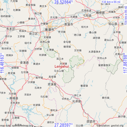
Lengshui GPS coordinates[2]
27° 54' 32.724" North, 117° 11' 5.1" East
| Map corner | latitude | longitude |
|---|---|---|
| Upper-left | 28.52864°, | 116.48163° |
| Center: | 27.90909°, | 117.18475° |
| Lower-right: | 27.28597°, | 117.88788° |
| Map W x H: | 138.2×138.2 km | = 85.9×85.9mi |
| max Lat: | 53.31946° ⇑74.6% North |
| Lengshui: | 27.90909° |
| min Lat: | ⇓25.4% South 18.22056° |
| min Long | Lengshui | max Long |
| 75.07348° | 117.18475° | 134.28917° |
| W 67.1%⇐ | ⇒32.9% E |
Elevation
Elevation of Lengshui is 173 m = 568 ft, and this is 311.8 m = 1023 ft below average elevation for this country.
| Max E: |
5622 m = 18445 ft | 49% |
| Avg. | 484.8 m = 1591 ft | |
| Lengshui | 173 m = 568 ft | |
Min E: |
-3 m = -10 ft | 51% |
See also: China elevation on elevation.city.
Geographical zone
Lengshui is located in North temperate zone (between Tropic of Cancer and the Arctic Circle). Distance of this Northern Tropic circle is 497.3 km =309 mi to South.| Distance of | km | miles | from Lengshui |
|---|---|---|---|
| North Pole | 6903.9 | 4289.9 | to North |
| Arctic Circle | 4298 | 2670.7 | to North |
| Tropic Cancer | 497.3 | 309 | to South |
| Equator | 3103.2 | 1928.2 | to South |


Nearby cities:
15 places around Lengshui: (largest is in red/bold)
• Erkou
6.6 km =4.1 mi,  324°
324°
• Gangkou
34.7 km =21.6 mi,  25°
25°
• Gaotian
36.9 km =22.9 mi,  243°
243°
• Heyuan
24.7 km =15.3 mi,  292°
292°
• Jintun
24.5 km =15.2 mi,  9°
9°
• Longhushan
31.4 km =19.5 mi, 319°
• Luohe
33.5 km =20.8 mi,  358°
358°
• Pengwan
21.6 km =13.4 mi,  343°
343°
• Shangqing
21.2 km =13.2 mi, 315°
• Songshi
30.5 km =19 mi, 240°
• Taiyuan
33.6 km =20.9 mi,  70°
70°
• Tangwan
19 km =11.8 mi, 11°
• Wenfang
20.9 km =13 mi,  46°
46°
• Yujia
33.5 km =20.8 mi,  331°
331°
• Zhangping
25.2 km =15.7 mi, 67°
Sources, notices
• [Note1] Compared only with cities in China existing in our database
• [Src1] Map data: © OpenStreetMap contributors (CC-BY-SA)
• [Src2] Other city data from geonames.org with taken over terms of usage.
• [Src3] Geographical zone / Annual Mean Temperature by Robert A. Rohde @ Wikipedia
