Dongxia geodata
Dongxia (Anhui) is a seat of a fourth-order administrative division; located in China in Asia/Shanghai (GMT+8) time zone. In our database, there are 1268 cities with bigger population. Compared to other cities in China, 56% of cities are located further ↓South; 76.5% of cities are located further ←West and 84.3% of cities have higher elevation than Dongxia. Note1


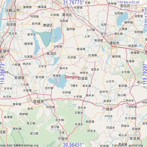
Dongxia GPS coordinates[2]
31° 10' 4.944" North, 119° 5' 23.424" East
| Map corner | latitude | longitude |
|---|---|---|
| Upper-left | 31.76775°, | 118.38672° |
| Center: | 31.16804°, | 119.08984° |
| Lower-right: | 30.56451°, | 119.79297° |
| Map W x H: | 133.8×133.8 km | = 83.1×83.1mi |
| max Lat: | 53.31946° ⇑44% North |
| Dongxia: | 31.16804° |
| min Lat: | ⇓56% South 18.22056° |
| min Long | Dongxia | max Long |
| 75.07348° | 119.08984° | 134.28917° |
| W 76.5%⇐ | ⇒23.5% E |
Elevation
Elevation of Dongxia is 17 m = 56 ft, and this is 467.8 m = 1535 ft below average elevation for this country.
| Max E: |
5622 m = 18445 ft | 84.3% |
| Avg. | 484.8 m = 1591 ft | |
| Dongxia | 17 m = 56 ft | |
Min E: |
-3 m = -10 ft | 15.7% |
See also: China elevation on elevation.city.
Geographical zone
Dongxia is located in North temperate zone (between Tropic of Cancer and the Arctic Circle). Distance of this Northern Tropic circle is 859.6 km =534.1 mi to South.| Distance of | km | miles | from Dongxia |
|---|---|---|---|
| North Pole | 6541.5 | 4064.7 | to North |
| Arctic Circle | 3935.6 | 2445.5 | to North |
| Tropic Cancer | 859.6 | 534.1 | to South |
| Equator | 3465.6 | 2153.4 | to South |


Nearby cities:
15 places around Dongxia: (largest is in red/bold)
• Biqiao
18.2 km =11.3 mi,  200°
200°
• Dingbu
15.5 km =9.6 mi,  25°
25°
• Dongba
14.8 km =9.2 mi,  346°
346°
• Feili
10.8 km =6.7 mi,  178°
178°
• Gangnan
21.6 km =13.4 mi,  68°
68°
• Gucheng
19.3 km =12 mi,  322°
322°
• Lingda
20 km =12.4 mi,  78°
78°
• Liqiao
16.9 km =10.5 mi,  288°
288°
• Meizhu
15.4 km =9.6 mi,  47°
47°
• Nanfeng
16.2 km =10.1 mi,  132°
132°
• Shizi
21.2 km =13.2 mi,  170°
170°
• Shuiming
16 km =9.9 mi,  159°
159°
• Taocheng
17.1 km =10.6 mi,  116°
116°
• Xinfa
4.1 km =2.5 mi,  18°
18°
• Zhongqiao
9.7 km =6 mi, 84°
Sources, notices
• [Note1] Compared only with cities in China existing in our database
• [Src1] Map data: © OpenStreetMap contributors (CC-BY-SA)
• [Src2] Other city data from geonames.org with taken over terms of usage.
• [Src3] Geographical zone / Annual Mean Temperature by Robert A. Rohde @ Wikipedia
