Lingda geodata
Lingda (Anhui) is a seat of a fourth-order administrative division; located in China in Asia/Shanghai (GMT+8) time zone. In our database, there are 1268 cities with bigger population. Compared to other cities in China, 56.3% of cities are located further ↓South; 77.6% of cities are located further ←West and 75.3% of cities have higher elevation than Lingda. Note1


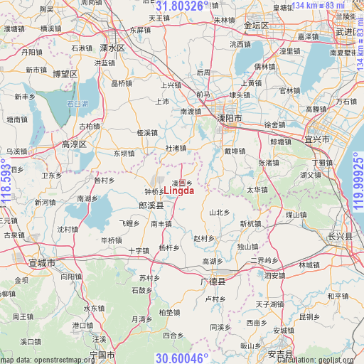
Lingda GPS coordinates[2]
31° 12' 13.572" North, 119° 17' 46.032" East
| Map corner | latitude | longitude |
|---|---|---|
| Upper-left | 31.80326°, | 118.593° |
| Center: | 31.20377°, | 119.29612° |
| Lower-right: | 30.60046°, | 119.99925° |
| Map W x H: | 133.7×133.7 km | = 83.1×83.1mi |
| max Lat: | 53.31946° ⇑43.7% North |
| Lingda: | 31.20377° |
| min Lat: | ⇓56.3% South 18.22056° |
| min Long | Lingda | max Long |
| 75.07348° | 119.29612° | 134.28917° |
| W 77.6%⇐ | ⇒22.4% E |
Elevation
Elevation of Lingda is 36 m = 118 ft, and this is 448.8 m = 1472 ft below average elevation for this country.
| Max E: |
5622 m = 18445 ft | 75.3% |
| Avg. | 484.8 m = 1591 ft | |
| Lingda | 36 m = 118 ft | |
Min E: |
-3 m = -10 ft | 24.7% |
See also: China elevation on elevation.city.
Geographical zone
Lingda is located in North temperate zone (between Tropic of Cancer and the Arctic Circle). Distance of this Northern Tropic circle is 863.6 km =536.6 mi to South.| Distance of | km | miles | from Lingda |
|---|---|---|---|
| North Pole | 6537.5 | 4062.2 | to North |
| Arctic Circle | 3931.6 | 2443 | to North |
| Tropic Cancer | 863.6 | 536.6 | to South |
| Equator | 3469.5 | 2155.8 | to South |


Nearby cities:
15 places around Lingda: (largest is in red/bold)
• Daibu
22.5 km =14 mi,  58°
58°
• Dingbu
16.3 km =10.1 mi,  307°
307°
• Dongchong
21.8 km =13.5 mi,  159°
159°
• Dongxia
20 km =12.4 mi,  258°
258°
• Gangnan
4.1 km =2.5 mi,  6°
6°
• Meizhu
10.4 km =6.5 mi, 308°
• Nanfeng
16.8 km =10.4 mi,  207°
207°
• Shezhu
12.5 km =7.8 mi, 6°
• Shezhu
12.9 km =8 mi,  349°
349°
• Taocheng
12.5 km =7.8 mi,  200°
200°
• Tianmuhu
19.2 km =11.9 mi,  45°
45°
• Xinfa
18.3 km =11.4 mi,  269°
269°
• Yaxi
22.5 km =14 mi,  324°
324°
• Zhongqiao
10.5 km =6.5 mi,  252°
252°
• Zhoucheng
17 km =10.6 mi,  23°
23°
Sources, notices
• [Note1] Compared only with cities in China existing in our database
• [Src1] Map data: © OpenStreetMap contributors (CC-BY-SA)
• [Src2] Other city data from geonames.org with taken over terms of usage.
• [Src3] Geographical zone / Annual Mean Temperature by Robert A. Rohde @ Wikipedia
