Dongshan geodata
Dongshan (Jiangxi) is a seat of a third-order administrative division; located in China in Asia/Shanghai (GMT+8) time zone. In our database, there are 1268 cities with bigger population. Compared to other cities in China, 83.2% of cities are located further ↑North; 51.8% of cities are located further ←West and 53.5% of cities have higher elevation than Dongshan. Note1


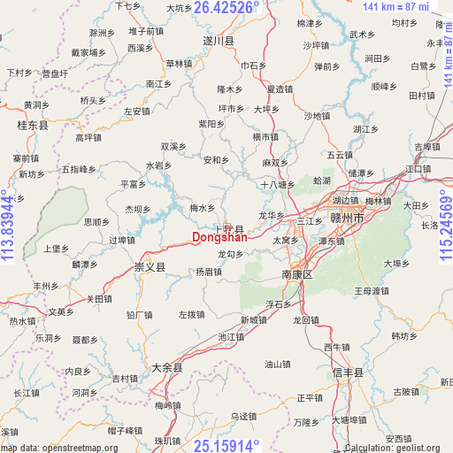
Dongshan GPS coordinates[2]
25° 47' 38.004" North, 114° 32' 33.216" East
| Map corner | latitude | longitude |
|---|---|---|
| Upper-left | 26.42526°, | 113.83944° |
| Center: | 25.79389°, | 114.54256° |
| Lower-right: | 25.15914°, | 115.24569° |
| Map W x H: | 140.8×140.8 km | = 87.5×87.5mi |
| max Lat: | 53.31946° ⇑83.2% North |
| Dongshan: | 25.79389° |
| min Lat: | ⇓16.8% South 18.22056° |
| min Long | Dongshan | max Long |
| 75.07348° | 114.54256° | 134.28917° |
| W 51.8%⇐ | ⇒48.2% E |
Elevation
Elevation of Dongshan is 140 m = 459 ft, and this is 344.8 m = 1131 ft below average elevation for this country.
| Max E: |
5622 m = 18445 ft | 53.5% |
| Avg. | 484.8 m = 1591 ft | |
| Dongshan | 140 m = 459 ft | |
Min E: |
-3 m = -10 ft | 46.5% |
See also: China elevation on elevation.city.
Geographical zone
Dongshan is located in North temperate zone (between Tropic of Cancer and the Arctic Circle). Distance of this Northern Tropic circle is 262.1 km =162.9 mi to South.| Distance of | km | miles | from Dongshan |
|---|---|---|---|
| North Pole | 7139.1 | 4436 | to North |
| Arctic Circle | 4533.2 | 2816.8 | to North |
| Tropic Cancer | 262.1 | 162.9 | to South |
| Equator | 2868 | 1782.1 | to South |


Nearby cities:
15 places around Dongshan: (largest is in red/bold)
• Dabu
54 km =33.6 mi,  102°
102°
• Datang
57.1 km =35.5 mi,  181°
181°
• Datian
59 km =36.7 mi,  83°
83°
• Ganzhou
39.5 km =24.5 mi, 81°
• Hengshui
24.9 km =15.5 mi,  245°
245°
• Jiading
56 km =34.8 mi,  136°
136°
• Kongjiang
57.4 km =35.7 mi,  172°
172°
• Maodian
51.8 km =32.2 mi, 76°
• Meilin
47.7 km =29.6 mi, 79°
• Meiling
58.5 km =36.4 mi,  198°
198°
• Nan’an
47.4 km =29.5 mi, 202°
• Quanjiang
57.4 km =35.7 mi,  357°
357°
• Rongjiang
25.4 km =15.8 mi,  125°
125°
• Wangmudu
49.8 km =30.9 mi,  114°
114°
• Youshan
48.3 km =30 mi, 180°
Sources, notices
• [Note1] Compared only with cities in China existing in our database
• [Src1] Map data: © OpenStreetMap contributors (CC-BY-SA)
• [Src2] Other city data from geonames.org with taken over terms of usage.
• [Src3] Geographical zone / Annual Mean Temperature by Robert A. Rohde @ Wikipedia
