Quanjiang geodata
Quanjiang (Jiangxi) is a seat of a third-order administrative division; located in China in Asia/Shanghai (GMT+8) time zone. In our database, there are 1268 cities with bigger population. Compared to other cities in China, 81.2% of cities are located further ↑North; 51.6% of cities are located further ←West and 59.9% of cities have higher elevation than Quanjiang. Note1


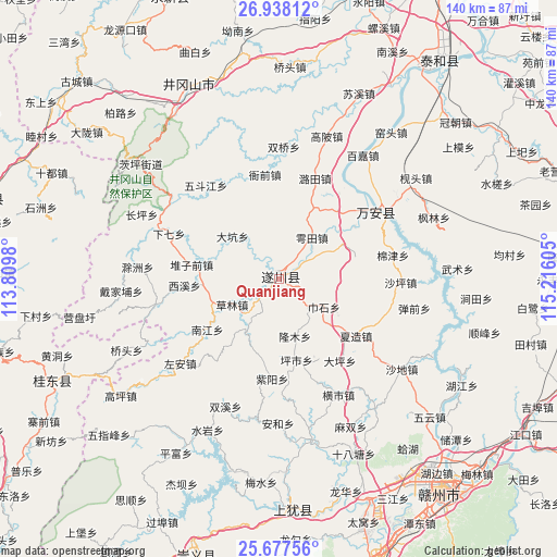
Quanjiang GPS coordinates[2]
26° 18' 34.38" North, 114° 30' 46.512" East
| Map corner | latitude | longitude |
|---|---|---|
| Upper-left | 26.93812°, | 113.8098° |
| Center: | 26.30955°, | 114.51292° |
| Lower-right: | 25.67756°, | 115.21605° |
| Map W x H: | 140.2×140.2 km | = 87.1×87.1mi |
| max Lat: | 53.31946° ⇑81.2% North |
| Quanjiang: | 26.30955° |
| min Lat: | ⇓18.8% South 18.22056° |
| min Long | Quanjiang | max Long |
| 75.07348° | 114.51292° | 134.28917° |
| W 51.6%⇐ | ⇒48.4% E |
Elevation
Elevation of Quanjiang is 99 m = 325 ft, and this is 385.8 m = 1266 ft below average elevation for this country.
| Max E: |
5622 m = 18445 ft | 59.9% |
| Avg. | 484.8 m = 1591 ft | |
| Quanjiang | 99 m = 325 ft | |
Min E: |
-3 m = -10 ft | 40.1% |
See also: China elevation on elevation.city.
Geographical zone
Quanjiang is located in North temperate zone (between Tropic of Cancer and the Arctic Circle). Distance of this Northern Tropic circle is 319.4 km =198.5 mi to South.| Distance of | km | miles | from Quanjiang |
|---|---|---|---|
| North Pole | 7081.7 | 4400.4 | to North |
| Arctic Circle | 4475.8 | 2781.1 | to North |
| Tropic Cancer | 319.4 | 198.5 | to South |
| Equator | 2925.3 | 1817.7 | to South |


Nearby cities:
15 places around Quanjiang: (largest is in red/bold)
• Bailu
63.7 km =39.6 mi,  96°
96°
• Baoshan
49.4 km =30.7 mi,  84°
84°
• Chayuan
67.2 km =41.8 mi,  73°
73°
• Chengjiang
66.9 km =41.6 mi,  35°
35°
• Dongshan
57.4 km =35.7 mi,  177°
177°
• Furong
29.7 km =18.5 mi,  58°
58°
• Ganzhou
66.4 km =41.3 mi,  140°
140°
• Guidong Chengguanzhen
62.6 km =38.9 mi,  245°
245°
• Jiantian
50.6 km =31.4 mi,  94°
94°
• Maodian
69.5 km =43.2 mi,  130°
130°
• Shangyi
68.7 km =42.7 mi, 62°
• Shuicha
60 km =37.3 mi, 66°
• Shunfeng
53.2 km =33.1 mi, 104°
• Xiaping
52.8 km =32.8 mi,  332°
332°
• Yongfeng
69.4 km =43.1 mi, 90°
Sources, notices
• [Note1] Compared only with cities in China existing in our database
• [Src1] Map data: © OpenStreetMap contributors (CC-BY-SA)
• [Src2] Other city data from geonames.org with taken over terms of usage.
• [Src3] Geographical zone / Annual Mean Temperature by Robert A. Rohde @ Wikipedia
