Hengshui geodata
Hengshui (Jiangxi) is a seat of a third-order administrative division; located in China in Asia/Shanghai (GMT+8) time zone. In our database, there are 1268 cities with bigger population. Compared to other cities in China, 83.5% of cities are located further ↑North; 50.4% of cities are located further ←West and 70.4% of cities have lower elevation than Hengshui. Note1


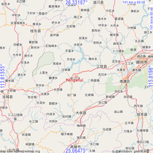
Hengshui GPS coordinates[2]
25° 42' 0" North, 114° 19' 0.012" East
| Map corner | latitude | longitude |
|---|---|---|
| Upper-left | 26.33187°, | 113.61355° |
| Center: | 25.7°, | 114.31667° |
| Lower-right: | 25.06475°, | 115.0198° |
| Map W x H: | 140.9×140.9 km | = 87.6×87.6mi |
| max Lat: | 53.31946° ⇑83.5% North |
| Hengshui: | 25.7° |
| min Lat: | ⇓16.5% South 18.22056° |
| min Long | Hengshui | max Long |
| 75.07348° | 114.31667° | 134.28917° |
| W 50.4%⇐ | ⇒49.6% E |
Elevation
Elevation of Hengshui is 418 m = 1371 ft, and this is 66.8 m = 219 ft below average elevation for this country.
| Max E: |
5622 m = 18445 ft | 29.6% |
| Avg. | 484.8 m = 1591 ft | |
| Hengshui | 418 m = 1371 ft | |
Min E: |
-3 m = -10 ft | 70.4% |
See also: China elevation on elevation.city.
Geographical zone
Hengshui is located in North temperate zone (between Tropic of Cancer and the Arctic Circle). Distance of this Northern Tropic circle is 251.7 km =156.4 mi to South.| Distance of | km | miles | from Hengshui |
|---|---|---|---|
| North Pole | 7149.5 | 4442.5 | to North |
| Arctic Circle | 4543.6 | 2823.3 | to North |
| Tropic Cancer | 251.7 | 156.4 | to South |
| Equator | 2857.6 | 1775.6 | to South |


Nearby cities:
15 places around Hengshui: (largest is in red/bold)
• Changjiang
57 km =35.4 mi,  223°
223°
• Datang
51.1 km =31.8 mi,  155°
155°
• Dengfang
50.3 km =31.3 mi,  165°
165°
• Dongshan
24.9 km =15.5 mi,  65°
65°
• Guidong Chengguanzhen
56.5 km =35.1 mi,  318°
318°
• Huangkeng
56.2 km =34.9 mi, 160°
• Kongjiang
55.4 km =34.4 mi,  147°
147°
• Lanhe
54.7 km =34 mi,  198°
198°
• Maozifeng
53.6 km =33.3 mi,  189°
189°
• Meiling
45.2 km =28.1 mi, 174°
• Nan’an
33.7 km =20.9 mi, 172°
• Rongjiang
43.7 km =27.2 mi,  95°
95°
• Wujing
57.8 km =35.9 mi, 149°
• Youshan
44 km =27.3 mi, 149°
• Zhuji
57.4 km =35.7 mi,  175°
175°
Sources, notices
• [Note1] Compared only with cities in China existing in our database
• [Src1] Map data: © OpenStreetMap contributors (CC-BY-SA)
• [Src2] Other city data from geonames.org with taken over terms of usage.
• [Src3] Geographical zone / Annual Mean Temperature by Robert A. Rohde @ Wikipedia
