Shishan geodata
Shishan (Jiangxi) is a seat of a fourth-order administrative division; located in China in Asia/Shanghai (GMT+8) time zone. In our database, there are 1268 cities with bigger population. Compared to other cities in China, 77.7% of cities are located further ↑North; 63.1% of cities are located further ←West and 60.3% of cities have higher elevation than Shishan. Note1


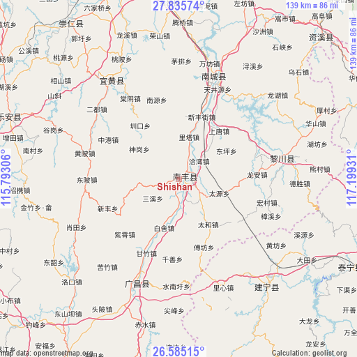
Shishan GPS coordinates[2]
27° 12' 43.92" North, 116° 29' 46.248" East
| Map corner | latitude | longitude |
|---|---|---|
| Upper-left | 27.83574°, | 115.79306° |
| Center: | 27.2122°, | 116.49618° |
| Lower-right: | 26.58515°, | 117.19931° |
| Map W x H: | 139.1×139.1 km | = 86.4×86.4mi |
| max Lat: | 53.31946° ⇑77.7% North |
| Shishan: | 27.2122° |
| min Lat: | ⇓22.3% South 18.22056° |
| min Long | Shishan | max Long |
| 75.07348° | 116.49618° | 134.28917° |
| W 63.1%⇐ | ⇒36.9% E |
Elevation
Elevation of Shishan is 97 m = 318 ft, and this is 387.8 m = 1272 ft below average elevation for this country.
| Max E: |
5622 m = 18445 ft | 60.3% |
| Avg. | 484.8 m = 1591 ft | |
| Shishan | 97 m = 318 ft | |
Min E: |
-3 m = -10 ft | 39.7% |
See also: China elevation on elevation.city.
Geographical zone
Shishan is located in North temperate zone (between Tropic of Cancer and the Arctic Circle). Distance of this Northern Tropic circle is 419.8 km =260.9 mi to South.| Distance of | km | miles | from Shishan |
|---|---|---|---|
| North Pole | 6981.3 | 4338 | to North |
| Arctic Circle | 4375.5 | 2718.8 | to North |
| Tropic Cancer | 419.8 | 260.9 | to South |
| Equator | 3025.7 | 1880.1 | to South |


Nearby cities:
15 places around Shishan: (largest is in red/bold)
• Baishe
20 km =12.4 mi,  197°
197°
• Dongping
21.4 km =13.3 mi,  59°
59°
• Fufang
28.3 km =17.6 mi,  159°
159°
• Laixi
8 km =5 mi,  91°
91°
• Lita
16.8 km =10.4 mi,  13°
13°
• Qiawan
10.4 km =6.5 mi,  48°
48°
• Qincheng
3.4 km =2.1 mi, 89°
• Sangtian
11.9 km =7.4 mi,  144°
144°
• Sanxi
12.8 km =8 mi,  233°
233°
• Shangtang
24.3 km =15.1 mi,  39°
39°
• Taihe
21.1 km =13.1 mi,  147°
147°
• Xinfengjie
25.6 km =15.9 mi,  21°
21°
• Zhenkou
25.7 km =16 mi,  323°
323°
• Zhuliang
30.3 km =18.8 mi, 19°
• Zixiao
30.3 km =18.8 mi,  224°
224°
Sources, notices
• [Note1] Compared only with cities in China existing in our database
• [Src1] Map data: © OpenStreetMap contributors (CC-BY-SA)
• [Src2] Other city data from geonames.org with taken over terms of usage.
• [Src3] Geographical zone / Annual Mean Temperature by Robert A. Rohde @ Wikipedia
