Diaojingyan geodata
Diaojingyan (Hunan) is a seat of a fourth-order administrative division; located in China in Asia/Shanghai (GMT+8) time zone. In our database, there are 1268 cities with bigger population. Compared to other cities in China, 64.6% of cities are located further ↑North; 71.6% of cities are located further →East and 65.5% of cities have lower elevation than Diaojingyan. Note1


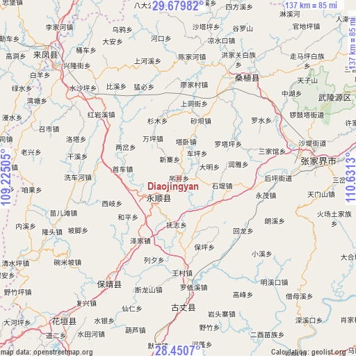
Diaojingyan GPS coordinates[2]
29° 4' 1.524" North, 109° 55' 41.412" East
| Map corner | latitude | longitude |
|---|---|---|
| Upper-left | 29.67982°, | 109.22505° |
| Center: | 29.06709°, | 109.92817° |
| Lower-right: | 28.4507°, | 110.6313° |
| Map W x H: | 136.7×136.7 km | = 84.9×84.9mi |
| max Lat: | 53.31946° ⇑64.6% North |
| Diaojingyan: | 29.06709° |
| min Lat: | ⇓35.4% South 18.22056° |
| min Long | Diaojingyan | max Long |
| 75.07348° | 109.92817° | 134.28917° |
| W 28.4%⇐ | ⇒71.6% E |
Elevation
Elevation of Diaojingyan is 335 m = 1099 ft, and this is 149.8 m = 491 ft below average elevation for this country.
| Max E: |
5622 m = 18445 ft | 34.5% |
| Avg. | 484.8 m = 1591 ft | |
| Diaojingyan | 335 m = 1099 ft | |
Min E: |
-3 m = -10 ft | 65.5% |
See also: China elevation on elevation.city.
Geographical zone
Diaojingyan is located in North temperate zone (between Tropic of Cancer and the Arctic Circle). Distance of this Northern Tropic circle is 626 km =389 mi to South.| Distance of | km | miles | from Diaojingyan |
|---|---|---|---|
| North Pole | 6775.1 | 4209.9 | to North |
| Arctic Circle | 4169.2 | 2590.6 | to North |
| Tropic Cancer | 626 | 389 | to South |
| Equator | 3232 | 2008.3 | to South |


Nearby cities:
15 places around Diaojingyan: (largest is in red/bold)
• Cheping
12.1 km =7.5 mi,  36°
36°
• Daming
12.8 km =8 mi,  69°
69°
• Guancangping
12.8 km =8 mi,  355°
355°
• Kesha
3.7 km =2.3 mi,  30°
30°
• Liandonggang
8 km =5 mi,  213°
213°
• Lingxi
10.7 km =6.6 mi,  229°
229°
• Macha
11.8 km =7.3 mi,  103°
103°
• Shaoha
16.3 km =10.1 mi,  252°
252°
• Shidixi
17.2 km =10.7 mi, 99°
• Shiziqiao
16.8 km =10.4 mi,  125°
125°
• Tawo
14.5 km =9 mi,  11°
11°
• Xiangjiazhai
17.2 km =10.7 mi, 25°
• Ximi
18.8 km =11.7 mi,  156°
156°
• Xinzhaiping
8.3 km =5.2 mi,  334°
334°
• Yanbanpu
9.7 km =6 mi,  286°
286°
Sources, notices
• [Note1] Compared only with cities in China existing in our database
• [Src1] Map data: © OpenStreetMap contributors (CC-BY-SA)
• [Src2] Other city data from geonames.org with taken over terms of usage.
• [Src3] Geographical zone / Annual Mean Temperature by Robert A. Rohde @ Wikipedia
