Lingxi geodata
Lingxi (Hunan) is a seat of a third-order administrative division; located in China in Asia/Shanghai (GMT+8) time zone. In our database, there are 1268 cities with bigger population. Compared to other cities in China, 65.4% of cities are located further ↑North; 72.1% of cities are located further →East and 59.3% of cities have lower elevation than Lingxi. Note1


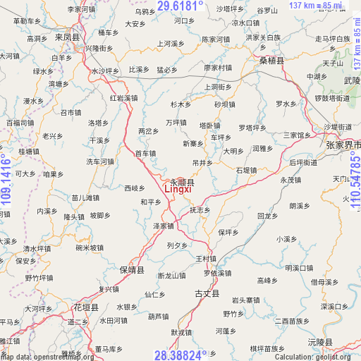
Lingxi GPS coordinates[2]
29° 0' 18" North, 109° 50' 40.992" East
| Map corner | latitude | longitude |
|---|---|---|
| Upper-left | 29.6181°, | 109.1416° |
| Center: | 29.005°, | 109.84472° |
| Lower-right: | 28.38824°, | 110.54785° |
| Map W x H: | 136.7×136.7 km | = 84.9×84.9mi |
| max Lat: | 53.31946° ⇑65.4% North |
| Lingxi: | 29.005° |
| min Lat: | ⇓34.6% South 18.22056° |
| min Long | Lingxi | max Long |
| 75.07348° | 109.84472° | 134.28917° |
| W 27.9%⇐ | ⇒72.1% E |
Elevation
Elevation of Lingxi is 251 m = 823 ft, and this is 233.8 m = 767 ft below average elevation for this country.
| Max E: |
5622 m = 18445 ft | 40.7% |
| Avg. | 484.8 m = 1591 ft | |
| Lingxi | 251 m = 823 ft | |
Min E: |
-3 m = -10 ft | 59.3% |
See also: China elevation on elevation.city.
Geographical zone
Lingxi is located in North temperate zone (between Tropic of Cancer and the Arctic Circle). Distance of this Northern Tropic circle is 619.1 km =384.7 mi to South.| Distance of | km | miles | from Lingxi |
|---|---|---|---|
| North Pole | 6782 | 4214.1 | to North |
| Arctic Circle | 4176.1 | 2594.9 | to North |
| Tropic Cancer | 619.1 | 384.7 | to South |
| Equator | 3225.1 | 2004 | to South |


Nearby cities:
15 places around Lingxi: (largest is in red/bold)
• Daba
9.1 km =5.7 mi,  208°
208°
• Diaojingyan
10.7 km =6.6 mi,  49°
49°
• Duishan
20.9 km =13 mi,  240°
240°
• Fuzhiping
14.4 km =8.9 mi,  147°
147°
• Guancangping
21 km =13 mi,  20°
20°
• Heping
13.7 km =8.5 mi, 235°
• Kesha
14.2 km =8.8 mi,  44°
44°
• Liandonggang
3.7 km =2.3 mi,  85°
85°
• Macha
20.1 km =12.5 mi,  77°
77°
• Shaoha
7.7 km =4.8 mi,  284°
284°
• Ximi
18.8 km =11.7 mi,  123°
123°
• Xinzhaiping
15.1 km =9.4 mi, 17°
• Xiqi
17.5 km =10.9 mi,  261°
261°
• Yanbanpu
9.7 km =6 mi,  353°
353°
• Zejia
18.1 km =11.2 mi,  201°
201°
Sources, notices
• [Note1] Compared only with cities in China existing in our database
• [Src1] Map data: © OpenStreetMap contributors (CC-BY-SA)
• [Src2] Other city data from geonames.org with taken over terms of usage.
• [Src3] Geographical zone / Annual Mean Temperature by Robert A. Rohde @ Wikipedia
