Deqing geodata
Deqing (Zhejiang) is a seat of a third-order administrative division; located in China in Asia/Shanghai (GMT+8) time zone. With population of 87,576 people, there are 487 cities with bigger population in this country. Compared to other cities in China, 50.8% of cities are located further ↓South; 81.7% of cities are located further ←West and 91.2% of cities have higher elevation than Deqing. Note1


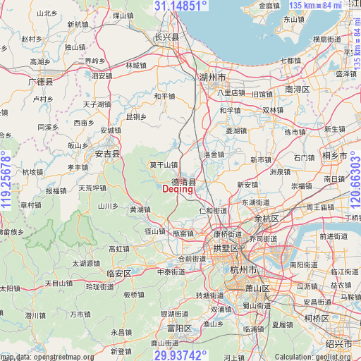
Deqing GPS coordinates[2]
30° 32' 41.46" North, 119° 57' 35.64" East
| Map corner | latitude | longitude |
|---|---|---|
| Upper-left | 31.14851°, | 119.25678° |
| Center: | 30.54485°, | 119.9599° |
| Lower-right: | 29.93742°, | 120.66303° |
| Map W x H: | 134.7×134.7 km | = 83.7×83.7mi |
| max Lat: | 53.31946° ⇑49.2% North |
| Deqing: | 30.54485° |
| min Lat: | ⇓50.8% South 18.22056° |
| min Long | Deqing | max Long |
| 75.07348° | 119.9599° | 134.28917° |
| W 81.7%⇐ | ⇒18.3% E |
Elevation
Elevation of Deqing is 9 m = 30 ft, and this is 475.8 m = 1561 ft below average elevation for this country.
| Max E: |
5622 m = 18445 ft | 91.2% |
| Avg. | 484.8 m = 1591 ft | |
| Deqing | 9 m = 30 ft | |
Min E: |
-3 m = -10 ft | 8.8% |
See also: Deqing elevation on elevation.city.
Geographical zone
Deqing is located in North temperate zone (between Tropic of Cancer and the Arctic Circle). Distance of this Northern Tropic circle is 790.3 km =491.1 mi to South.| Distance of | km | miles | from Deqing |
|---|---|---|---|
| North Pole | 6610.8 | 4107.8 | to North |
| Arctic Circle | 4004.9 | 2488.5 | to North |
| Tropic Cancer | 790.3 | 491.1 | to South |
| Equator | 3396.3 | 2110.4 | to South |


Nearby cities:
15 places around Deqing: (largest is in red/bold)
• Chengguan
11.5 km =7.1 mi,  88°
88°
• Daixi
14 km =8.7 mi,  20°
20°
• Fatou
10.4 km =6.5 mi,  270°
270°
• Huanghu
18.1 km =11.2 mi,  234°
234°
• Leidian
17.5 km =10.9 mi,  98°
98°
• Liangzhu
20.2 km =12.6 mi,  155°
155°
• Luoshe
15.9 km =9.9 mi,  51°
51°
• Moganshan
8.9 km =5.5 mi,  314°
314°
• Nanlu
13.6 km =8.5 mi,  321°
321°
• Panbanqiao
19.7 km =12.2 mi,  205°
205°
• Pingyao
16 km =9.9 mi,  178°
178°
• Renhe
15.6 km =9.7 mi,  134°
134°
• Sanhe
10.1 km =6.3 mi,  136°
136°
• Shuangxi
20.1 km =12.5 mi,  219°
219°
• Wukang
0.4 km =0.2 mi,  188°
188°
Sources, notices
• [Note1] Compared only with cities in China existing in our database
• [Src1] Map data: © OpenStreetMap contributors (CC-BY-SA)
• [Src2] Other city data from geonames.org with taken over terms of usage.
• [Src3] Geographical zone / Annual Mean Temperature by Robert A. Rohde @ Wikipedia
