Sanhe geodata
Sanhe (Zhejiang) is a seat of a fourth-order administrative division; located in China in Asia/Shanghai (GMT+8) time zone. In our database, there are 1268 cities with bigger population. Compared to other cities in China, 50.2% of cities are located further ↓South; 82.1% of cities are located further ←West and 94.3% of cities have higher elevation than Sanhe. Note1


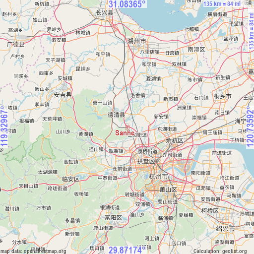
Sanhe GPS coordinates[2]
30° 28' 46.488" North, 120° 1' 58.044" East
| Map corner | latitude | longitude |
|---|---|---|
| Upper-left | 31.08365°, | 119.32967° |
| Center: | 30.47958°, | 120.03279° |
| Lower-right: | 29.87174°, | 120.73592° |
| Map W x H: | 134.8×134.8 km | = 83.8×83.8mi |
| max Lat: | 53.31946° ⇑49.8% North |
| Sanhe: | 30.47958° |
| min Lat: | ⇓50.2% South 18.22056° |
| min Long | Sanhe | max Long |
| 75.07348° | 120.03279° | 134.28917° |
| W 82.1%⇐ | ⇒17.9% E |
Elevation
Elevation of Sanhe is 7 m = 23 ft, and this is 477.8 m = 1568 ft below average elevation for this country.
| Max E: |
5622 m = 18445 ft | 94.3% |
| Avg. | 484.8 m = 1591 ft | |
| Sanhe | 7 m = 23 ft | |
Min E: |
-3 m = -10 ft | 5.7% |
See also: China elevation on elevation.city.
Geographical zone
Sanhe is located in North temperate zone (between Tropic of Cancer and the Arctic Circle). Distance of this Northern Tropic circle is 783.1 km =486.6 mi to South.| Distance of | km | miles | from Sanhe |
|---|---|---|---|
| North Pole | 6618.1 | 4112.3 | to North |
| Arctic Circle | 4012.2 | 2493.1 | to North |
| Tropic Cancer | 783.1 | 486.6 | to South |
| Equator | 3389 | 2105.8 | to South |


Nearby cities:
15 places around Sanhe: (largest is in red/bold)
• Chengguan
8.9 km =5.5 mi,  30°
30°
• Chongxian
16.7 km =10.4 mi,  127°
127°
• Deqing
10.1 km =6.3 mi,  316°
316°
• Kangqiao
16.6 km =10.3 mi,  140°
140°
• Leidian
11.4 km =7.1 mi,  65°
65°
• Liangzhu
11.2 km =7 mi,  173°
173°
• Luoshe
18 km =11.2 mi,  17°
17°
• Panbanqiao
18.7 km =11.6 mi,  235°
235°
• Pingyao
11 km =6.8 mi,  217°
217°
• Renhe
5.5 km =3.4 mi, 132°
• Sandun
17.7 km =11 mi, 165°
• Tangqi
14.2 km =8.8 mi,  90°
90°
• Wukang
9.8 km =6.1 mi,  314°
314°
• Xiangfu
17.8 km =11.1 mi,  159°
159°
• Xin’an
18.8 km =11.7 mi, 71°
Sources, notices
• [Note1] Compared only with cities in China existing in our database
• [Src1] Map data: © OpenStreetMap contributors (CC-BY-SA)
• [Src2] Other city data from geonames.org with taken over terms of usage.
• [Src3] Geographical zone / Annual Mean Temperature by Robert A. Rohde @ Wikipedia
