Liulang geodata
Liulang (Hunan) is a seat of a fourth-order administrative division; located in China in Asia/Shanghai (GMT+8) time zone. In our database, there are 1268 cities with bigger population. Compared to other cities in China, 62% of cities are located further ↑North; 69% of cities are located further →East and 84.7% of cities have lower elevation than Liulang. Note1


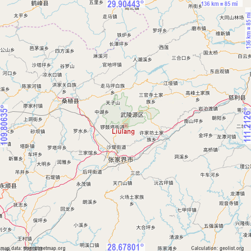
Liulang GPS coordinates[2]
29° 17' 35.016" North, 110° 30' 34.092" East
| Map corner | latitude | longitude |
|---|---|---|
| Upper-left | 29.90443°, | 109.80635° |
| Center: | 29.29306°, | 110.50947° |
| Lower-right: | 28.67801°, | 111.2126° |
| Map W x H: | 136.4×136.4 km | = 84.8×84.8mi |
| max Lat: | 53.31946° ⇑62% North |
| Liulang: | 29.29306° |
| min Lat: | ⇓38% South 18.22056° |
| min Long | Liulang | max Long |
| 75.07348° | 110.50947° | 134.28917° |
| W 31%⇐ | ⇒69% E |
Elevation
Elevation of Liulang is 960 m = 3150 ft, and this is 475.2 m = 1559 ft above average elevation for this country.
| Max E: |
5622 m = 18445 ft | 15.3% |
| Liulang | 960 m 3150 ft | |
| Avg. | 484.8 m = 1591 ft | |
Min E: |
-3 m = -10 ft | 84.7% |
See also: China elevation on elevation.city.
Geographical zone
Liulang is located in North temperate zone (between Tropic of Cancer and the Arctic Circle). Distance of this Northern Tropic circle is 651.2 km =404.6 mi to South.| Distance of | km | miles | from Liulang |
|---|---|---|---|
| North Pole | 6750 | 4194.3 | to North |
| Arctic Circle | 4144.1 | 2575 | to North |
| Tropic Cancer | 651.2 | 404.6 | to South |
| Equator | 3257.1 | 2023.9 | to South |


Nearby cities:
15 places around Liulang: (largest is in red/bold)
• Hezuoqiao
10.5 km =6.5 mi,  142°
142°
• Huochiyu
19.2 km =11.9 mi,  349°
349°
• Jianxin
16.9 km =10.5 mi,  166°
166°
• Jiaoziya
18.2 km =11.3 mi,  268°
268°
• Shadi
12.3 km =7.6 mi,  201°
201°
• Tianzishan
14.8 km =9.2 mi,  331°
331°
• Wulingyuan
7.1 km =4.4 mi,  28°
28°
• Xianchiyu
19.4 km =12.1 mi, 349°
• Xinqiao
11.5 km =7.1 mi,  181°
181°
• Xujiafang
15.1 km =9.4 mi,  111°
111°
• Yanghe
19.1 km =11.9 mi,  99°
99°
• Yinjiaxi
19.9 km =12.4 mi,  209°
209°
• Yujiazui
8.5 km =5.3 mi,  37°
37°
• Zhangjiajie
18.4 km =11.4 mi,  189°
189°
• Zhonghuping
14.6 km =9.1 mi,  302°
302°
Sources, notices
• [Note1] Compared only with cities in China existing in our database
• [Src1] Map data: © OpenStreetMap contributors (CC-BY-SA)
• [Src2] Other city data from geonames.org with taken over terms of usage.
• [Src3] Geographical zone / Annual Mean Temperature by Robert A. Rohde @ Wikipedia
