Datuan geodata
Datuan (Shandong) is a seat of a fourth-order administrative division; located in China in Asia/Shanghai (GMT+8) time zone. In our database, there are 1268 cities with bigger population. Compared to other cities in China, 79.5% of cities are located further ↓South; 91.8% of cities are located further ←West and 71.6% of cities have higher elevation than Datuan. Note1


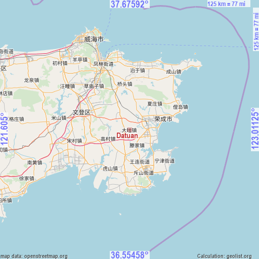
Datuan GPS coordinates[2]
37° 7' 2.388" North, 122° 18' 29.232" East
| Map corner | latitude | longitude |
|---|---|---|
| Upper-left | 37.67592°, | 121.605° |
| Center: | 37.11733°, | 122.30812° |
| Lower-right: | 36.55458°, | 123.01125° |
| Map W x H: | 124.7×124.7 km | = 77.5×77.5mi |
| max Lat: | 53.31946° ⇑20.5% North |
| Datuan: | 37.11733° |
| min Lat: | ⇓79.5% South 18.22056° |
| min Long | Datuan | max Long |
| 75.07348° | 122.30812° | 134.28917° |
| W 91.8%⇐ | ⇒8.2% E |
Elevation
Elevation of Datuan is 46 m = 151 ft, and this is 438.8 m = 1440 ft below average elevation for this country.
| Max E: |
5622 m = 18445 ft | 71.6% |
| Avg. | 484.8 m = 1591 ft | |
| Datuan | 46 m = 151 ft | |
Min E: |
-3 m = -10 ft | 28.4% |
See also: China elevation on elevation.city.
Geographical zone
Datuan is located in North temperate zone (between Tropic of Cancer and the Arctic Circle). Distance of this Northern Tropic circle is 1521.1 km =945.2 mi to South.| Distance of | km | miles | from Datuan |
|---|---|---|---|
| North Pole | 5880 | 3653.7 | to North |
| Arctic Circle | 3274.1 | 2034.4 | to North |
| Tropic Cancer | 1521.1 | 945.2 | to South |
| Equator | 4127.1 | 2564.5 | to South |


Nearby cities:
15 places around Datuan: (largest is in red/bold)
• Chishan
21.6 km =13.4 mi,  160°
160°
• Dashuipo
9.3 km =5.8 mi,  324°
324°
• Dongshan
20.7 km =12.9 mi,  145°
145°
• Gaocun
10.8 km =6.7 mi,  250°
250°
• Houjia
22.2 km =13.8 mi,  240°
240°
• Hushan
19.3 km =12 mi,  199°
199°
• Ningjin
22.5 km =14 mi,  130°
130°
• Shangzhuang
13.3 km =8.3 mi,  188°
188°
• Tengjia
7.3 km =4.5 mi, 150°
• Wanglian
15.4 km =9.6 mi, 161°
• Wendengying
21.3 km =13.2 mi,  299°
299°
• Xiazhuang
18.1 km =11.2 mi,  45°
45°
• Yatou
12.3 km =7.6 mi,  69°
69°
• Yaxi
15.8 km =9.8 mi,  18°
18°
• Yinzi
10.9 km =6.8 mi,  2°
2°
Sources, notices
• [Note1] Compared only with cities in China existing in our database
• [Src1] Map data: © OpenStreetMap contributors (CC-BY-SA)
• [Src2] Other city data from geonames.org with taken over terms of usage.
• [Src3] Geographical zone / Annual Mean Temperature by Robert A. Rohde @ Wikipedia
