Ningjin geodata
Ningjin (Shandong) is a seat of a third-order administrative division; located in China in Asia/Shanghai (GMT+8) time zone. In our database, there are 1268 cities with bigger population. Compared to other cities in China, 79.2% of cities are located further ↓South; 92.1% of cities are located further ←West and 73.3% of cities have higher elevation than Ningjin. Note1


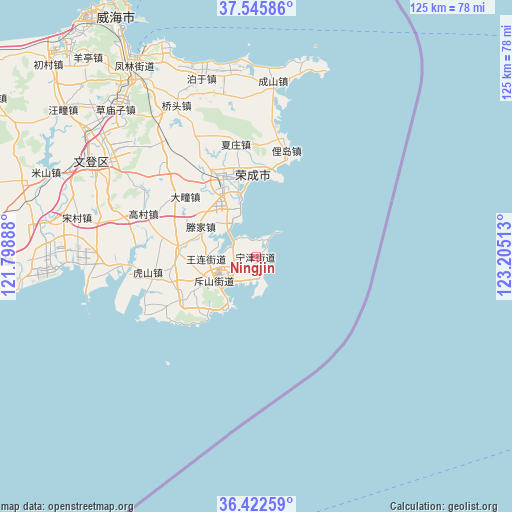
Ningjin GPS coordinates[2]
36° 59' 10.68" North, 122° 30' 7.2" East
| Map corner | latitude | longitude |
|---|---|---|
| Upper-left | 37.54586°, | 121.79888° |
| Center: | 36.9863°, | 122.502° |
| Lower-right: | 36.42259°, | 123.20513° |
| Map W x H: | 124.9×124.9 km | = 77.6×77.6mi |
| max Lat: | 53.31946° ⇑20.8% North |
| Ningjin: | 36.9863° |
| min Lat: | ⇓79.2% South 18.22056° |
| min Long | Ningjin | max Long |
| 75.07348° | 122.502° | 134.28917° |
| W 92.1%⇐ | ⇒7.9% E |
Elevation
Elevation of Ningjin is 41 m = 135 ft, and this is 443.8 m = 1456 ft below average elevation for this country.
| Max E: |
5622 m = 18445 ft | 73.3% |
| Avg. | 484.8 m = 1591 ft | |
| Ningjin | 41 m = 135 ft | |
Min E: |
-3 m = -10 ft | 26.7% |
See also: China elevation on elevation.city.
Geographical zone
Ningjin is located in North temperate zone (between Tropic of Cancer and the Arctic Circle). Distance of this Northern Tropic circle is 1506.6 km =936.2 mi to South.| Distance of | km | miles | from Ningjin |
|---|---|---|---|
| North Pole | 5894.6 | 3662.7 | to North |
| Arctic Circle | 3288.7 | 2043.5 | to North |
| Tropic Cancer | 1506.6 | 936.2 | to South |
| Equator | 4112.5 | 2555.4 | to South |


Nearby cities:
15 places around Ningjin: (largest is in red/bold)
• Chishan
11.7 km =7.3 mi,  239°
239°
• Datuan
22.5 km =14 mi,  310°
310°
• Dongshan
6.1 km =3.8 mi,  245°
245°
• Gangwan
13.7 km =8.5 mi,  210°
210°
• Gaocun
29.5 km =18.3 mi,  291°
291°
• Hushan
24 km =14.9 mi,  261°
261°
• Lidao
27.8 km =17.3 mi,  15°
15°
• Renhe
20.9 km =13 mi, 239°
• Shangzhuang
19.2 km =11.9 mi,  274°
274°
• Taoyuan
7.9 km =4.9 mi,  220°
220°
• Tengjia
15.9 km =9.9 mi,  301°
301°
• Wanglian
12.3 km =7.6 mi, 269°
• Xiazhuang
27.7 km =17.2 mi,  350°
350°
• Yatou
19.8 km =12.3 mi,  343°
343°
• Yinzi
30.5 km =19 mi,  326°
326°
Sources, notices
• [Note1] Compared only with cities in China existing in our database
• [Src1] Map data: © OpenStreetMap contributors (CC-BY-SA)
• [Src2] Other city data from geonames.org with taken over terms of usage.
• [Src3] Geographical zone / Annual Mean Temperature by Robert A. Rohde @ Wikipedia
