Dandian geodata
Dandian (Hubei) is a seat of a fourth-order administrative division; located in China in Asia/Shanghai (GMT+8) time zone. In our database, there are 1268 cities with bigger population. Compared to other cities in China, 52.7% of cities are located further ↓South; 55.3% of cities are located further ←West and 70.8% of cities have higher elevation than Dandian. Note1


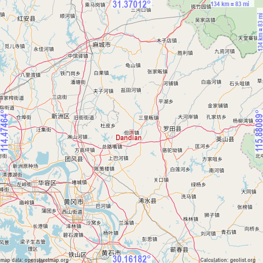
Dandian GPS coordinates[2]
30° 46' 4.332" North, 115° 10' 39.936" East
| Map corner | latitude | longitude |
|---|---|---|
| Upper-left | 31.37012°, | 114.47464° |
| Center: | 30.76787°, | 115.17776° |
| Lower-right: | 30.16182°, | 115.88089° |
| Map W x H: | 134.4×134.4 km | = 83.5×83.5mi |
| max Lat: | 53.31946° ⇑47.3% North |
| Dandian: | 30.76787° |
| min Lat: | ⇓52.7% South 18.22056° |
| min Long | Dandian | max Long |
| 75.07348° | 115.17776° | 134.28917° |
| W 55.3%⇐ | ⇒44.7% E |
Elevation
Elevation of Dandian is 49 m = 161 ft, and this is 435.8 m = 1430 ft below average elevation for this country.
| Max E: |
5622 m = 18445 ft | 70.8% |
| Avg. | 484.8 m = 1591 ft | |
| Dandian | 49 m = 161 ft | |
Min E: |
-3 m = -10 ft | 29.2% |
See also: China elevation on elevation.city.
Geographical zone
Dandian is located in North temperate zone (between Tropic of Cancer and the Arctic Circle). Distance of this Northern Tropic circle is 815.1 km =506.5 mi to South.| Distance of | km | miles | from Dandian |
|---|---|---|---|
| North Pole | 6586 | 4092.3 | to North |
| Arctic Circle | 3980.1 | 2473.1 | to North |
| Tropic Cancer | 815.1 | 506.5 | to South |
| Equator | 3421.1 | 2125.8 | to South |


Nearby cities:
15 places around Dandian: (largest is in red/bold)
• Chencelou
22.7 km =14.1 mi,  213°
213°
• Daqi
9.6 km =6 mi,  7°
7°
• Dupi
12.5 km =7.8 mi,  284°
284°
• Fengshan
20.6 km =12.8 mi,  83°
83°
• Jiamiao
9.7 km =6 mi,  288°
288°
• Luotuo’ao
22.4 km =13.9 mi,  113°
113°
• Macaomiao
19.6 km =12.2 mi,  231°
231°
• Pinghu
23.3 km =14.5 mi,  47°
47°
• Sanlifan
11.3 km =7 mi, 48°
• Shangbahe
14.8 km =9.2 mi, 208°
• Tuanbei
6.5 km =4 mi,  132°
132°
• Wanggang
16.1 km =10 mi,  181°
181°
• Yantianhe
22.5 km =14 mi,  358°
358°
• Zhuwa
20.1 km =12.5 mi,  196°
196°
• Zongluzui
13.7 km =8.5 mi, 234°
Sources, notices
• [Note1] Compared only with cities in China existing in our database
• [Src1] Map data: © OpenStreetMap contributors (CC-BY-SA)
• [Src2] Other city data from geonames.org with taken over terms of usage.
• [Src3] Geographical zone / Annual Mean Temperature by Robert A. Rohde @ Wikipedia
