Fengshan geodata
Fengshan (Hubei) is a seat of a fourth-order administrative division; located in China in Asia/Shanghai (GMT+8) time zone. In our database, there are 1268 cities with bigger population. Compared to other cities in China, 52.9% of cities are located further ↓South; 56.3% of cities are located further ←West and 61.3% of cities have higher elevation than Fengshan. Note1


Fengshan GPS coordinates[2]
30° 47' 18.528" North, 115° 23' 31.704" East
| Map corner | latitude | longitude |
|---|---|---|
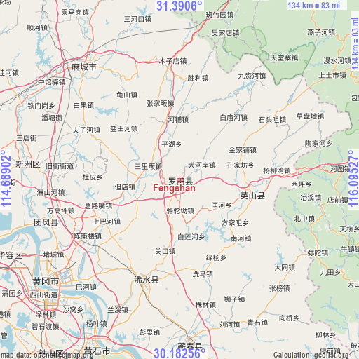
| Upper-left | 31.3906°, | 114.68902° |
| Center: | 30.78848°, | 115.39214° |
| Lower-right: | 30.18256°, | 116.09527° |
| Map W x H: | 134.3×134.3 km | = 83.5×83.5mi |
| max Lat: | 53.31946° ⇑47.1% North |
| Fengshan: | 30.78848° |
| min Lat: | ⇓52.9% South 18.22056° |
| min Long | Fengshan | max Long |
| 75.07348° | 115.39214° | 134.28917° |
| W 56.3%⇐ | ⇒43.7% E |
Elevation
Elevation of Fengshan is 91 m = 299 ft, and this is 393.8 m = 1292 ft below average elevation for this country.
| Max E: |
5622 m = 18445 ft | 61.3% |
| Avg. | 484.8 m = 1591 ft | |
| Fengshan | 91 m = 299 ft | |
Min E: |
-3 m = -10 ft | 38.7% |
See also: China elevation on elevation.city.
Geographical zone
Fengshan is located in North temperate zone (between Tropic of Cancer and the Arctic Circle). Distance of this Northern Tropic circle is 817.4 km =507.9 mi to South.| Distance of | km | miles | from Fengshan |
|---|---|---|---|
| North Pole | 6583.7 | 4090.9 | to North |
| Arctic Circle | 3977.8 | 2471.7 | to North |
| Tropic Cancer | 817.4 | 507.9 | to South |
| Equator | 3423.4 | 2127.2 | to South |


Nearby cities:
15 places around Fengshan: (largest is in red/bold)
• Bailian
22 km =13.7 mi,  167°
167°
• Bailianhe
21.5 km =13.4 mi, 168°
• Caihe
25 km =15.5 mi,  176°
176°
• Dahe’an
9.9 km =6.2 mi,  54°
54°
• Dandian
20.6 km =12.8 mi,  263°
263°
• Daqi
20.5 km =12.7 mi,  290°
290°
• Fengshan
11.3 km =7 mi,  14°
14°
• Hepu
22.9 km =14.2 mi,  357°
357°
• Hongshan
24.7 km =15.3 mi,  94°
94°
• Kongjiafang
23.3 km =14.5 mi,  75°
75°
• Kuanghe
18.2 km =11.3 mi,  120°
120°
• Luotuo’ao
11.3 km =7 mi, 179°
• Pinghu
13.8 km =8.6 mi,  346°
346°
• Sanlifan
13.1 km =8.1 mi, 293°
• Tuanbei
17.1 km =10.6 mi,  247°
247°
Sources, notices
• [Note1] Compared only with cities in China existing in our database
• [Src1] Map data: © OpenStreetMap contributors (CC-BY-SA)
• [Src2] Other city data from geonames.org with taken over terms of usage.
• [Src3] Geographical zone / Annual Mean Temperature by Robert A. Rohde @ Wikipedia
