Xinba geodata
Xinba (Jiangsu) is a seat of a fourth-order administrative division; located in China in Asia/Shanghai (GMT+8) time zone. In our database, there are 1268 cities with bigger population. Compared to other cities in China, 62.9% of cities are located further ↓South; 79.5% of cities are located further ←West and 97.2% of cities have higher elevation than Xinba. Note1


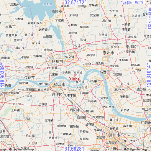
Xinba GPS coordinates[2]
32° 16' 45.156" North, 119° 36' 25.236" East
| Map corner | latitude | longitude |
|---|---|---|
| Upper-left | 32.87172°, | 118.90389° |
| Center: | 32.27921°, | 119.60701° |
| Lower-right: | 31.68281°, | 120.31014° |
| Map W x H: | 132.2×132.2 km | = 82.1×82.1mi |
| max Lat: | 53.31946° ⇑37.1% North |
| Xinba: | 32.27921° |
| min Lat: | ⇓62.9% South 18.22056° |
| min Long | Xinba | max Long |
| 75.07348° | 119.60701° | 134.28917° |
| W 79.5%⇐ | ⇒20.5% E |
Elevation
Elevation of Xinba is 5 m = 16 ft, and this is 479.8 m = 1574 ft below average elevation for this country.
| Max E: |
5622 m = 18445 ft | 97.2% |
| Avg. | 484.8 m = 1591 ft | |
| Xinba | 5 m = 16 ft | |
Min E: |
-3 m = -10 ft | 2.8% |
See also: China elevation on elevation.city.
Geographical zone
Xinba is located in North temperate zone (between Tropic of Cancer and the Arctic Circle). Distance of this Northern Tropic circle is 983.2 km =610.9 mi to South.| Distance of | km | miles | from Xinba |
|---|---|---|---|
| North Pole | 6418 | 3988 | to North |
| Arctic Circle | 3812.1 | 2368.7 | to North |
| Tropic Cancer | 983.2 | 610.9 | to South |
| Equator | 3589.1 | 2230.2 | to South |


Nearby cities:
15 places around Xinba: (largest is in red/bold)
• Dagang
10.7 km =6.6 mi,  154°
154°
• Dalu
13.8 km =8.6 mi,  121°
121°
• Daqiao
13.7 km =8.5 mi,  42°
42°
• Dinggang
16.8 km =10.4 mi, 153°
• Gaoqiao
6.8 km =4.2 mi,  144°
144°
• Hangji
12.1 km =7.5 mi,  324°
324°
• Lidian
5.6 km =3.5 mi,  328°
328°
• Shatou
8.7 km =5.4 mi,  292°
292°
• Shiqiao
14.7 km =9.1 mi,  284°
284°
• Tangwang
17.1 km =10.6 mi,  306°
306°
• Xiangshan
12 km =7.5 mi,  218°
218°
• Xiannü
17.1 km =10.6 mi,  345°
345°
• Xinba
13.9 km =8.6 mi,  97°
97°
• Zhengdonglu
16 km =9.9 mi,  233°
233°
• Zhenjiang
16.2 km =10.1 mi,  241°
241°
Sources, notices
• [Note1] Compared only with cities in China existing in our database
• [Src1] Map data: © OpenStreetMap contributors (CC-BY-SA)
• [Src2] Other city data from geonames.org with taken over terms of usage.
• [Src3] Geographical zone / Annual Mean Temperature by Robert A. Rohde @ Wikipedia
