Dalang geodata
Dalang (Guangdong) is a seat of a fourth-order administrative division; located in China in Asia/Shanghai (GMT+8) time zone. In our database, there are 1268 cities with bigger population. Compared to other cities in China, 88.6% of cities are located further ↑North; 60.1% of cities are located further →East and 69.4% of cities have lower elevation than Dalang. Note1


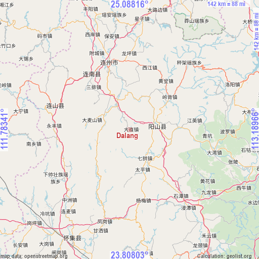
Dalang GPS coordinates[2]
24° 26' 58.992" North, 112° 29' 11.508" East
| Map corner | latitude | longitude |
|---|---|---|
| Upper-left | 25.08816°, | 111.78341° |
| Center: | 24.44972°, | 112.48653° |
| Lower-right: | 23.80803°, | 113.18966° |
| Map W x H: | 142.3×142.3 km | = 88.4×88.4mi |
| max Lat: | 53.31946° ⇑88.6% North |
| Dalang: | 24.44972° |
| min Lat: | ⇓11.4% South 18.22056° |
| min Long | Dalang | max Long |
| 75.07348° | 112.48653° | 134.28917° |
| W 39.9%⇐ | ⇒60.1% E |
Elevation
Elevation of Dalang is 399 m = 1309 ft, and this is 85.8 m = 281 ft below average elevation for this country.
| Max E: |
5622 m = 18445 ft | 30.6% |
| Avg. | 484.8 m = 1591 ft | |
| Dalang | 399 m = 1309 ft | |
Min E: |
-3 m = -10 ft | 69.4% |
See also: China elevation on elevation.city.
Geographical zone
Dalang is located in North temperate zone (between Tropic of Cancer and the Arctic Circle). Distance of this Northern Tropic circle is 112.6 km =70 mi to South.| Distance of | km | miles | from Dalang |
|---|---|---|---|
| North Pole | 7288.5 | 4528.9 | to North |
| Arctic Circle | 4682.6 | 2909.6 | to North |
| Tropic Cancer | 112.6 | 70 | to South |
| Equator | 2718.6 | 1689.3 | to South |


Nearby cities:
15 places around Dalang: (largest is in red/bold)
• Damaishan
22.4 km =13.9 mi,  281°
281°
• Dubu
22.4 km =13.9 mi,  125°
125°
• Huangben
33.6 km =20.9 mi,  36°
36°
• Jiubei
27.3 km =17 mi,  333°
333°
• Libu
13.9 km =8.6 mi, 329°
• Lingbei
28.6 km =17.8 mi,  50°
50°
• Qigong
18 km =11.2 mi,  156°
156°
• Qinglian
27.3 km =17 mi,  86°
86°
• Sanpai
30.8 km =19.1 mi,  318°
318°
• Taiping
23 km =14.3 mi, 162°
• Woshui
29.7 km =18.5 mi,  297°
297°
• Xiaojiang
21.4 km =13.3 mi,  30°
30°
• Xijiang
35.3 km =21.9 mi,  16°
16°
• Yangcheng
16.1 km =10 mi,  78°
78°
• Zhaigang
16 km =9.9 mi, 296°
Sources, notices
• [Note1] Compared only with cities in China existing in our database
• [Src1] Map data: © OpenStreetMap contributors (CC-BY-SA)
• [Src2] Other city data from geonames.org with taken over terms of usage.
• [Src3] Geographical zone / Annual Mean Temperature by Robert A. Rohde @ Wikipedia
