Dubu geodata
Dubu (Guangdong) is a seat of a fourth-order administrative division; located in China in Asia/Shanghai (GMT+8) time zone. In our database, there are 1268 cities with bigger population. Compared to other cities in China, 89.1% of cities are located further ↑North; 59.3% of cities are located further →East and 58.6% of cities have higher elevation than Dubu. Note1


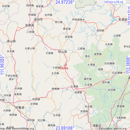
Dubu GPS coordinates[2]
24° 19' 59.988" North, 112° 40' 0.012" East
| Map corner | latitude | longitude |
|---|---|---|
| Upper-left | 24.97236°, | 111.96355° |
| Center: | 24.33333°, | 112.66667° |
| Lower-right: | 23.69106°, | 113.3698° |
| Map W x H: | 142.5×142.5 km | = 88.5×88.5mi |
| max Lat: | 53.31946° ⇑89.1% North |
| Dubu: | 24.33333° |
| min Lat: | ⇓10.9% South 18.22056° |
| min Long | Dubu | max Long |
| 75.07348° | 112.66667° | 134.28917° |
| W 40.7%⇐ | ⇒59.3% E |
Elevation
Elevation of Dubu is 107 m = 351 ft, and this is 377.8 m = 1240 ft below average elevation for this country.
| Max E: |
5622 m = 18445 ft | 58.6% |
| Avg. | 484.8 m = 1591 ft | |
| Dubu | 107 m = 351 ft | |
Min E: |
-3 m = -10 ft | 41.4% |
See also: China elevation on elevation.city.
Geographical zone
Dubu is located in North temperate zone (between Tropic of Cancer and the Arctic Circle). Distance of this Northern Tropic circle is 99.7 km =62 mi to South.| Distance of | km | miles | from Dubu |
|---|---|---|---|
| North Pole | 7301.4 | 4536.9 | to North |
| Arctic Circle | 4695.6 | 2917.7 | to North |
| Tropic Cancer | 99.7 | 62 | to South |
| Equator | 2705.6 | 1681.2 | to South |


Nearby cities:
15 places around Dubu: (largest is in red/bold)
• Dalang
22.4 km =13.9 mi,  305°
305°
• Dawan
27.4 km =17 mi,  88°
88°
• Huanghua
27.5 km =17.1 mi,  120°
120°
• Jiangying
25.4 km =15.8 mi,  43°
43°
• Lingbei
31.5 km =19.6 mi,  6°
6°
• Mingjing
28.4 km =17.6 mi, 121°
• Qigong
11.5 km =7.1 mi,  252°
252°
• Qingkeng
26.1 km =16.2 mi,  68°
68°
• Qinglian
17.1 km =10.6 mi,  31°
31°
• Shitan
24.8 km =15.4 mi,  156°
156°
• Taiping
14.5 km =9 mi,  231°
231°
• Xiaojiang
32.1 km =19.9 mi,  346°
346°
• Yanbei
17.1 km =10.6 mi,  112°
112°
• Yangcheng
16.4 km =10.2 mi, 351°
• Yangmei
28.2 km =17.5 mi,  202°
202°
Sources, notices
• [Note1] Compared only with cities in China existing in our database
• [Src1] Map data: © OpenStreetMap contributors (CC-BY-SA)
• [Src2] Other city data from geonames.org with taken over terms of usage.
• [Src3] Geographical zone / Annual Mean Temperature by Robert A. Rohde @ Wikipedia
