Dafan geodata
Dafan (Hubei) is a seat of a fourth-order administrative division; located in China in Asia/Shanghai (GMT+8) time zone. In our database, there are 1268 cities with bigger population. Compared to other cities in China, 57.9% of cities are located further ↑North; 52.4% of cities are located further ←West and 65.2% of cities have higher elevation than Dafan. Note1


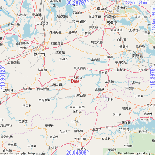
Dafan GPS coordinates[2]
29° 39' 31.788" North, 114° 39' 51.732" East
| Map corner | latitude | longitude |
|---|---|---|
| Upper-left | 30.26797°, | 113.96125° |
| Center: | 29.65883°, | 114.66437° |
| Lower-right: | 29.04598°, | 115.3675° |
| Map W x H: | 135.9×135.9 km | = 84.4×84.4mi |
| max Lat: | 53.31946° ⇑57.9% North |
| Dafan: | 29.65883° |
| min Lat: | ⇓42.1% South 18.22056° |
| min Long | Dafan | max Long |
| 75.07348° | 114.66437° | 134.28917° |
| W 52.4%⇐ | ⇒47.6% E |
Elevation
Elevation of Dafan is 72 m = 236 ft, and this is 412.8 m = 1354 ft below average elevation for this country.
| Max E: |
5622 m = 18445 ft | 65.2% |
| Avg. | 484.8 m = 1591 ft | |
| Dafan | 72 m = 236 ft | |
Min E: |
-3 m = -10 ft | 34.8% |
See also: China elevation on elevation.city.
Geographical zone
Dafan is located in North temperate zone (between Tropic of Cancer and the Arctic Circle). Distance of this Northern Tropic circle is 691.8 km =429.9 mi to South.| Distance of | km | miles | from Dafan |
|---|---|---|---|
| North Pole | 6709.3 | 4169 | to North |
| Arctic Circle | 4103.4 | 2549.7 | to North |
| Tropic Cancer | 691.8 | 429.9 | to South |
| Equator | 3297.8 | 2049.2 | to South |


Nearby cities:
15 places around Dafan: (largest is in red/bold)
• Chuangwang
18.7 km =11.6 mi,  193°
193°
• Cikou
13 km =8.1 mi,  75°
75°
• Dalu
23.4 km =14.5 mi,  253°
253°
• Damu
20.6 km =12.8 mi,  324°
324°
• Gaoqiao
26.4 km =16.4 mi,  326°
326°
• Guihua
31.6 km =19.6 mi,  281°
281°
• Honggangshan
25.1 km =15.6 mi,  128°
128°
• Huangshapu
9.4 km =5.8 mi,  9°
9°
• Jiugongshan
15.7 km =9.8 mi,  173°
173°
• Longgang
27.9 km =17.3 mi,  97°
97°
• Nanlinqiao
32 km =19.9 mi, 252°
• Tongyang
6.6 km =4.1 mi, 281°
• Wangying
22.6 km =14 mi,  44°
44°
• Xiapu
25.1 km =15.6 mi,  230°
230°
• Yanxia
21.6 km =13.4 mi,  117°
117°
Sources, notices
• [Note1] Compared only with cities in China existing in our database
• [Src1] Map data: © OpenStreetMap contributors (CC-BY-SA)
• [Src2] Other city data from geonames.org with taken over terms of usage.
• [Src3] Geographical zone / Annual Mean Temperature by Robert A. Rohde @ Wikipedia
