Chuangwang geodata
Chuangwang (Hubei) is a seat of a fourth-order administrative division; located in China in Asia/Shanghai (GMT+8) time zone. In our database, there are 1268 cities with bigger population. Compared to other cities in China, 59.8% of cities are located further ↑North; 52.2% of cities are located further ←West and 56% of cities have higher elevation than Chuangwang. Note1


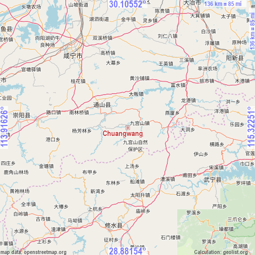
Chuangwang GPS coordinates[2]
29° 29' 43.368" North, 114° 37' 9.768" East
| Map corner | latitude | longitude |
|---|---|---|
| Upper-left | 30.10552°, | 113.91626° |
| Center: | 29.49538°, | 114.61938° |
| Lower-right: | 28.88154°, | 115.32251° |
| Map W x H: | 136.1×136.1 km | = 84.6×84.6mi |
| max Lat: | 53.31946° ⇑59.8% North |
| Chuangwang: | 29.49538° |
| min Lat: | ⇓40.2% South 18.22056° |
| min Long | Chuangwang | max Long |
| 75.07348° | 114.61938° | 134.28917° |
| W 52.2%⇐ | ⇒47.8% E |
Elevation
Elevation of Chuangwang is 124 m = 407 ft, and this is 360.8 m = 1184 ft below average elevation for this country.
| Max E: |
5622 m = 18445 ft | 56% |
| Avg. | 484.8 m = 1591 ft | |
| Chuangwang | 124 m = 407 ft | |
Min E: |
-3 m = -10 ft | 44% |
See also: China elevation on elevation.city.
Geographical zone
Chuangwang is located in North temperate zone (between Tropic of Cancer and the Arctic Circle). Distance of this Northern Tropic circle is 673.7 km =418.6 mi to South.| Distance of | km | miles | from Chuangwang |
|---|---|---|---|
| North Pole | 6727.5 | 4180.3 | to North |
| Arctic Circle | 4121.6 | 2561 | to North |
| Tropic Cancer | 673.7 | 418.6 | to South |
| Equator | 3279.6 | 2037.8 | to South |


Nearby cities:
15 places around Chuangwang: (largest is in red/bold)
• Bujia
30.9 km =19.2 mi,  221°
221°
• Chuantan
28.9 km =18 mi,  169°
169°
• Cikou
27.4 km =17 mi,  38°
38°
• Dafan
18.7 km =11.6 mi,  13°
13°
• Dalu
21.5 km =13.4 mi,  302°
302°
• Donglin
30.1 km =18.7 mi,  195°
195°
• Honggangshan
24.3 km =15.1 mi,  83°
83°
• Huangshapu
28 km =17.4 mi, 12°
• Jiugongshan
6.5 km =4 mi,  66°
66°
• Nanlinqiao
27.6 km =17.1 mi,  288°
288°
• Shangtang
20.4 km =12.7 mi, 173°
• Tongyang
19.6 km =12.2 mi,  353°
353°
• Xiapu
15.2 km =9.4 mi,  278°
278°
• Yangfanglin
24.8 km =15.4 mi,  267°
267°
• Yanxia
25 km =15.5 mi, 70°
Sources, notices
• [Note1] Compared only with cities in China existing in our database
• [Src1] Map data: © OpenStreetMap contributors (CC-BY-SA)
• [Src2] Other city data from geonames.org with taken over terms of usage.
• [Src3] Geographical zone / Annual Mean Temperature by Robert A. Rohde @ Wikipedia
