Xiapu geodata
Xiapu (Hubei) is a seat of a fourth-order administrative division; located in China in Asia/Shanghai (GMT+8) time zone. In our database, there are 1268 cities with bigger population. Compared to other cities in China, 59.6% of cities are located further ↑North; 51.4% of cities are located further ←West and 59.5% of cities have higher elevation than Xiapu. Note1


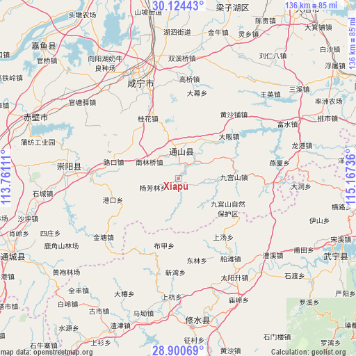
Xiapu GPS coordinates[2]
29° 30' 51.876" North, 114° 27' 51.228" East
| Map corner | latitude | longitude |
|---|---|---|
| Upper-left | 30.12443°, | 113.76111° |
| Center: | 29.51441°, | 114.46423° |
| Lower-right: | 28.90069°, | 115.16736° |
| Map W x H: | 136.1×136.1 km | = 84.6×84.6mi |
| max Lat: | 53.31946° ⇑59.6% North |
| Xiapu: | 29.51441° |
| min Lat: | ⇓40.4% South 18.22056° |
| min Long | Xiapu | max Long |
| 75.07348° | 114.46423° | 134.28917° |
| W 51.4%⇐ | ⇒48.6% E |
Elevation
Elevation of Xiapu is 101 m = 331 ft, and this is 383.8 m = 1259 ft below average elevation for this country.
| Max E: |
5622 m = 18445 ft | 59.5% |
| Avg. | 484.8 m = 1591 ft | |
| Xiapu | 101 m = 331 ft | |
Min E: |
-3 m = -10 ft | 40.5% |
See also: China elevation on elevation.city.
Geographical zone
Xiapu is located in North temperate zone (between Tropic of Cancer and the Arctic Circle). Distance of this Northern Tropic circle is 675.8 km =419.9 mi to South.| Distance of | km | miles | from Xiapu |
|---|---|---|---|
| North Pole | 6725.4 | 4179 | to North |
| Arctic Circle | 4119.5 | 2559.7 | to North |
| Tropic Cancer | 675.8 | 419.9 | to South |
| Equator | 3281.7 | 2039.2 | to South |


Nearby cities:
15 places around Xiapu: (largest is in red/bold)
• Baini
32.5 km =20.2 mi,  274°
274°
• Bujia
25.9 km =16.1 mi,  191°
191°
• Chuangwang
15.2 km =9.4 mi,  98°
98°
• Dafan
25.1 km =15.6 mi,  50°
50°
• Dalu
10 km =6.2 mi,  341°
341°
• Donglin
32 km =19.9 mi,  167°
167°
• Gangkou
26.7 km =16.6 mi,  251°
251°
• Gangkou
31.3 km =19.4 mi,  204°
204°
• Guihua
25.4 km =15.8 mi,  332°
332°
• Jiugongshan
21 km =13 mi,  88°
88°
• Lukou
25.7 km =16 mi,  284°
284°
• Nanlinqiao
12.9 km =8 mi,  299°
299°
• Shangtang
28.2 km =17.5 mi,  142°
142°
• Tongyang
21.6 km =13.4 mi,  36°
36°
• Yangfanglin
10.4 km =6.5 mi, 251°
Sources, notices
• [Note1] Compared only with cities in China existing in our database
• [Src1] Map data: © OpenStreetMap contributors (CC-BY-SA)
• [Src2] Other city data from geonames.org with taken over terms of usage.
• [Src3] Geographical zone / Annual Mean Temperature by Robert A. Rohde @ Wikipedia
