Dalu geodata
Dalu (Hubei) is a seat of a fourth-order administrative division; located in China in Asia/Shanghai (GMT+8) time zone. In our database, there are 1268 cities with bigger population. Compared to other cities in China, 58.6% of cities are located further ↑North; 51.2% of cities are located further ←West and 61.3% of cities have higher elevation than Dalu. Note1


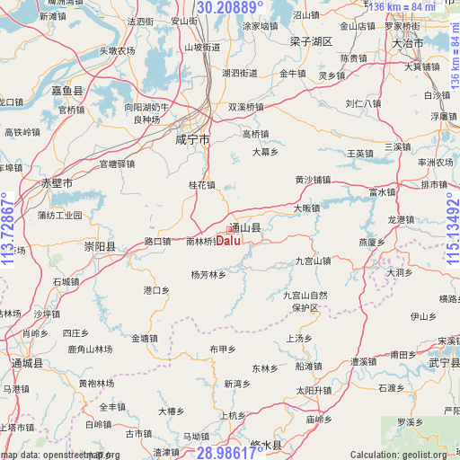
Dalu GPS coordinates[2]
29° 35' 57.768" North, 114° 25' 54.444" East
| Map corner | latitude | longitude |
|---|---|---|
| Upper-left | 30.20889°, | 113.72867° |
| Center: | 29.59938°, | 114.43179° |
| Lower-right: | 28.98617°, | 115.13492° |
| Map W x H: | 136×136 km | = 84.5×84.5mi |
| max Lat: | 53.31946° ⇑58.6% North |
| Dalu: | 29.59938° |
| min Lat: | ⇓41.4% South 18.22056° |
| min Long | Dalu | max Long |
| 75.07348° | 114.43179° | 134.28917° |
| W 51.2%⇐ | ⇒48.8% E |
Elevation
Elevation of Dalu is 91 m = 299 ft, and this is 393.8 m = 1292 ft below average elevation for this country.
| Max E: |
5622 m = 18445 ft | 61.3% |
| Avg. | 484.8 m = 1591 ft | |
| Dalu | 91 m = 299 ft | |
Min E: |
-3 m = -10 ft | 38.7% |
See also: China elevation on elevation.city.
Geographical zone
Dalu is located in North temperate zone (between Tropic of Cancer and the Arctic Circle). Distance of this Northern Tropic circle is 685.2 km =425.8 mi to South.| Distance of | km | miles | from Dalu |
|---|---|---|---|
| North Pole | 6715.9 | 4173.1 | to North |
| Arctic Circle | 4110 | 2553.8 | to North |
| Tropic Cancer | 685.2 | 425.8 | to South |
| Equator | 3291.1 | 2045 | to South |


Nearby cities:
15 places around Dalu: (largest is in red/bold)
• Chuangwang
21.5 km =13.4 mi,  122°
122°
• Dafan
23.4 km =14.5 mi,  73°
73°
• Damu
25.5 km =15.8 mi,  23°
23°
• Gangkou
28.4 km =17.6 mi,  231°
231°
• Gaoqiao
29.6 km =18.4 mi, 15°
• Guihua
15.6 km =9.7 mi,  327°
327°
• Huangshapu
28.7 km =17.8 mi,  56°
56°
• Jiugongshan
25.8 km =16 mi,  110°
110°
• Lukou
22 km =13.7 mi,  261°
261°
• Maqiao
24.3 km =15.1 mi,  342°
342°
• Nanlinqiao
8.6 km =5.3 mi,  249°
249°
• Tongyang
17.8 km =11.1 mi, 63°
• Xianning
29.1 km =18.1 mi, 338°
• Xiapu
10 km =6.2 mi,  161°
161°
• Yangfanglin
14.4 km =8.9 mi,  207°
207°
Sources, notices
• [Note1] Compared only with cities in China existing in our database
• [Src1] Map data: © OpenStreetMap contributors (CC-BY-SA)
• [Src2] Other city data from geonames.org with taken over terms of usage.
• [Src3] Geographical zone / Annual Mean Temperature by Robert A. Rohde @ Wikipedia
