Xinzhuang geodata
Xinzhuang (Tianjin) is a seat of a fourth-order administrative division; located in China in Asia/Shanghai (GMT+8) time zone. With population of 5,191 people, there are 866 cities with bigger population in this country. Compared to other cities in China, 82.8% of cities are located further ↓South; 68% of cities are located further ←West and 98.3% of cities have higher elevation than Xinzhuang. Note1


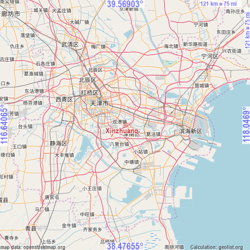
Xinzhuang GPS coordinates[2]
39° 1' 29.64" North, 117° 20' 37.572" East
| Map corner | latitude | longitude |
|---|---|---|
| Upper-left | 39.56903°, | 116.64065° |
| Center: | 39.0249°, | 117.34377° |
| Lower-right: | 38.47655°, | 118.0469° |
| Map W x H: | 121.5×121.5 km | = 75.5×75.5mi |
| max Lat: | 53.31946° ⇑17.2% North |
| Xinzhuang: | 39.0249° |
| min Lat: | ⇓82.8% South 18.22056° |
| min Long | Xinzhuang | max Long |
| 75.07348° | 117.34377° | 134.28917° |
| W 68%⇐ | ⇒32% E |
Elevation
Elevation of Xinzhuang is 4 m = 13 ft, and this is 480.8 m = 1577 ft below average elevation for this country.
| Max E: |
5622 m = 18445 ft | 98.3% |
| Avg. | 484.8 m = 1591 ft | |
| Xinzhuang | 4 m = 13 ft | |
Min E: |
-3 m = -10 ft | 1.7% |
See also: China elevation on elevation.city.
Geographical zone
Xinzhuang is located in North temperate zone (between Tropic of Cancer and the Arctic Circle). Distance of this Northern Tropic circle is 1733.2 km =1077 mi to South.| Distance of | km | miles | from Xinzhuang |
|---|---|---|---|
| North Pole | 5667.9 | 3521.9 | to North |
| Arctic Circle | 3062 | 1902.6 | to North |
| Tropic Cancer | 1733.2 | 1077 | to South |
| Equator | 4339.2 | 2696.3 | to South |


Nearby cities:
15 places around Xinzhuang: (largest is in red/bold)
• Beizhakou
8.9 km =5.5 mi,  150°
150°
• Chentangzhuang
8.7 km =5.4 mi,  302°
302°
• Cuijiamatou
6.7 km =4.2 mi,  326°
326°
• Darenzhuang
8.1 km =5 mi,  281°
281°
• Dongnigu
8.7 km =5.4 mi,  96°
96°
• Fengniancun
6.5 km =4 mi,  348°
348°
• Liulin
8 km =5 mi, 302°
• Luotuofangzi
7.1 km =4.4 mi,  23°
23°
• Shuanggang
3.6 km =2.2 mi,  306°
306°
• Shuangqiaohe
7.8 km =4.8 mi,  121°
121°
• Weiwangzhuang
8.4 km =5.2 mi,  89°
89°
• Xianshuigu
5.6 km =3.5 mi,  142°
142°
• Xiaodongzhuang
7.3 km =4.5 mi,  57°
57°
• Xinli
6.7 km =4.2 mi, 353°
• Zhangguizhuang
7.9 km =4.9 mi,  336°
336°
Sources, notices
• [Note1] Compared only with cities in China existing in our database
• [Src1] Map data: © OpenStreetMap contributors (CC-BY-SA)
• [Src2] Other city data from geonames.org with taken over terms of usage.
• [Src3] Geographical zone / Annual Mean Temperature by Robert A. Rohde @ Wikipedia
