Chongkan geodata
Chongkan (Chongqing) is a seat of a fourth-order administrative division; located in China in Asia/Shanghai (GMT+8) time zone. In our database, there are 1268 cities with bigger population. Compared to other cities in China, 52.5% of cities are located further ↑North; 88% of cities are located further →East and 60.5% of cities have lower elevation than Chongkan. Note1


Chongkan GPS coordinates[2]
30° 9' 20.124" North, 105° 36' 43.992" East
| Map corner | latitude | longitude |
|---|---|---|
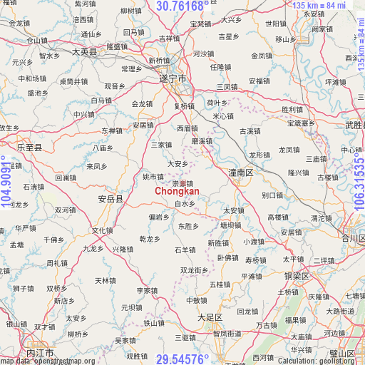
| Upper-left | 30.76168°, | 104.9091° |
| Center: | 30.15559°, | 105.61222° |
| Lower-right: | 29.54576°, | 106.31535° |
| Map W x H: | 135.2×135.2 km | = 84×84mi |
| max Lat: | 53.31946° ⇑52.5% North |
| Chongkan: | 30.15559° |
| min Lat: | ⇓47.5% South 18.22056° |
| min Long | Chongkan | max Long |
| 75.07348° | 105.61222° | 134.28917° |
| W 12%⇐ | ⇒88% E |
Elevation
Elevation of Chongkan is 266 m = 873 ft, and this is 218.8 m = 718 ft below average elevation for this country.
| Max E: |
5622 m = 18445 ft | 39.5% |
| Avg. | 484.8 m = 1591 ft | |
| Chongkan | 266 m = 873 ft | |
Min E: |
-3 m = -10 ft | 60.5% |
See also: China elevation on elevation.city.
Geographical zone
Chongkan is located in North temperate zone (between Tropic of Cancer and the Arctic Circle). Distance of this Northern Tropic circle is 747.1 km =464.2 mi to South.| Distance of | km | miles | from Chongkan |
|---|---|---|---|
| North Pole | 6654.1 | 4134.7 | to North |
| Arctic Circle | 4048.2 | 2515.4 | to North |
| Tropic Cancer | 747.1 | 464.2 | to South |
| Equator | 3353 | 2083.5 | to South |


Nearby cities:
15 places around Chongkan: (largest is in red/bold)
• Anju
26.3 km =16.3 mi,  325°
325°
• Baizi
11.9 km =7.4 mi,  125°
125°
• Guxi
31.6 km =19.6 mi,  52°
52°
• Huayan
11.6 km =7.2 mi,  14°
14°
• Longxing
30.4 km =18.9 mi,  69°
69°
• Mixin
29.1 km =18.1 mi,  30°
30°
• Qunli
27 km =16.8 mi, 53°
• Shanghe
30.9 km =19.2 mi,  89°
89°
• Shuangjiang
14.5 km =9 mi,  61°
61°
• Tai’an
21.4 km =13.3 mi,  117°
117°
• Tangba
23.6 km =14.7 mi, 130°
• Weixin
29.5 km =18.3 mi,  114°
114°
• Xinsheng
25.8 km =16 mi,  148°
148°
• Yuxi
24.5 km =15.2 mi,  40°
40°
• Zitong
21.1 km =13.1 mi,  83°
83°
Sources, notices
• [Note1] Compared only with cities in China existing in our database
• [Src1] Map data: © OpenStreetMap contributors (CC-BY-SA)
• [Src2] Other city data from geonames.org with taken over terms of usage.
• [Src3] Geographical zone / Annual Mean Temperature by Robert A. Rohde @ Wikipedia
