Huayan geodata
Huayan (Chongqing) is a seat of a fourth-order administrative division; located in China in Asia/Shanghai (GMT+8) time zone. In our database, there are 1268 cities with bigger population. Compared to other cities in China, 51.6% of cities are located further ↑North; 88% of cities are located further →East and 65.4% of cities have lower elevation than Huayan. Note1


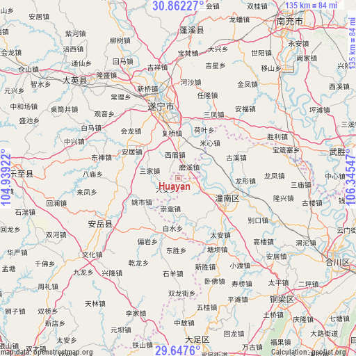
Huayan GPS coordinates[2]
30° 15' 24.516" North, 105° 38' 32.424" East
| Map corner | latitude | longitude |
|---|---|---|
| Upper-left | 30.86227°, | 104.93922° |
| Center: | 30.25681°, | 105.64234° |
| Lower-right: | 29.6476°, | 106.34547° |
| Map W x H: | 135.1×135.1 km | = 83.9×83.9mi |
| max Lat: | 53.31946° ⇑51.6% North |
| Huayan: | 30.25681° |
| min Lat: | ⇓48.4% South 18.22056° |
| min Long | Huayan | max Long |
| 75.07348° | 105.64234° | 134.28917° |
| W 12%⇐ | ⇒88% E |
Elevation
Elevation of Huayan is 333 m = 1093 ft, and this is 151.8 m = 498 ft below average elevation for this country.
| Max E: |
5622 m = 18445 ft | 34.6% |
| Avg. | 484.8 m = 1591 ft | |
| Huayan | 333 m = 1093 ft | |
Min E: |
-3 m = -10 ft | 65.4% |
See also: China elevation on elevation.city.
Geographical zone
Huayan is located in North temperate zone (between Tropic of Cancer and the Arctic Circle). Distance of this Northern Tropic circle is 758.3 km =471.2 mi to South.| Distance of | km | miles | from Huayan |
|---|---|---|---|
| North Pole | 6642.8 | 4127.6 | to North |
| Arctic Circle | 4036.9 | 2508.4 | to North |
| Tropic Cancer | 758.3 | 471.2 | to South |
| Equator | 3364.2 | 2090.4 | to South |


Nearby cities:
15 places around Huayan: (largest is in red/bold)
• Anju
20.7 km =12.9 mi,  299°
299°
• Baizi
19.3 km =12 mi,  159°
159°
• Baolong
28.8 km =17.9 mi,  67°
67°
• Chongkan
11.6 km =7.2 mi,  194°
194°
• Guxi
23.5 km =14.6 mi, 69°
• Longxing
25.6 km =15.9 mi,  91°
91°
• Mixin
18.2 km =11.3 mi,  41°
41°
• Qunli
19.4 km =12.1 mi,  75°
75°
• Shanghe
30 km =18.6 mi,  110°
110°
• Shuangjiang
10.8 km =6.7 mi, 113°
• Suining
28.7 km =17.8 mi,  346°
346°
• Tai’an
26.6 km =16.5 mi,  142°
142°
• Tangba
30.6 km =19 mi,  150°
150°
• Yuxi
15 km =9.3 mi,  60°
60°
• Zitong
20 km =12.4 mi,  115°
115°
Sources, notices
• [Note1] Compared only with cities in China existing in our database
• [Src1] Map data: © OpenStreetMap contributors (CC-BY-SA)
• [Src2] Other city data from geonames.org with taken over terms of usage.
• [Src3] Geographical zone / Annual Mean Temperature by Robert A. Rohde @ Wikipedia
