Baizi geodata
Baizi (Chongqing) is a seat of a fourth-order administrative division; located in China in Asia/Shanghai (GMT+8) time zone. In our database, there are 1268 cities with bigger population. Compared to other cities in China, 53% of cities are located further ↑North; 87.8% of cities are located further →East and 60.3% of cities have lower elevation than Baizi. Note1


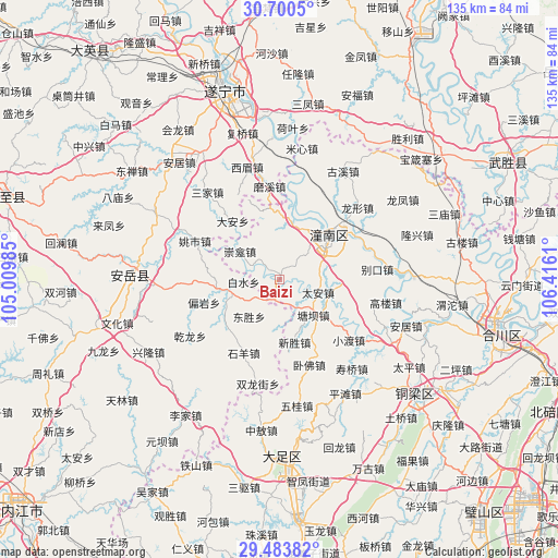
Baizi GPS coordinates[2]
30° 5' 38.508" North, 105° 42' 46.692" East
| Map corner | latitude | longitude |
|---|---|---|
| Upper-left | 30.7005°, | 105.00985° |
| Center: | 30.09403°, | 105.71297° |
| Lower-right: | 29.48382°, | 106.4161° |
| Map W x H: | 135.3×135.3 km | = 84.1×84.1mi |
| max Lat: | 53.31946° ⇑53% North |
| Baizi: | 30.09403° |
| min Lat: | ⇓47% South 18.22056° |
| min Long | Baizi | max Long |
| 75.07348° | 105.71297° | 134.28917° |
| W 12.2%⇐ | ⇒87.8% E |
Elevation
Elevation of Baizi is 263 m = 863 ft, and this is 221.8 m = 728 ft below average elevation for this country.
| Max E: |
5622 m = 18445 ft | 39.7% |
| Avg. | 484.8 m = 1591 ft | |
| Baizi | 263 m = 863 ft | |
Min E: |
-3 m = -10 ft | 60.3% |
See also: China elevation on elevation.city.
Geographical zone
Baizi is located in North temperate zone (between Tropic of Cancer and the Arctic Circle). Distance of this Northern Tropic circle is 740.2 km =459.9 mi to South.| Distance of | km | miles | from Baizi |
|---|---|---|---|
| North Pole | 6660.9 | 4138.9 | to North |
| Arctic Circle | 4055 | 2519.7 | to North |
| Tropic Cancer | 740.2 | 459.9 | to South |
| Equator | 3346.1 | 2079.2 | to South |


Nearby cities:
15 places around Baizi: (largest is in red/bold)
• Biekou
23.7 km =14.7 mi,  83°
83°
• Chongkan
11.9 km =7.4 mi,  305°
305°
• Gaolou
26.1 km =16.2 mi,  101°
101°
• Huayan
19.3 km =12 mi,  339°
339°
• Longxing
25.6 km =15.9 mi,  47°
47°
• Qunli
25.9 km =16.1 mi,  27°
27°
• Shanghe
22.5 km =14 mi,  70°
70°
• Shuangjiang
14.1 km =8.8 mi,  12°
12°
• Tai’an
9.8 km =6.1 mi,  108°
108°
• Tangba
11.8 km =7.3 mi,  136°
136°
• Weixin
18 km =11.2 mi, 107°
• Wofo
21.9 km =13.6 mi,  160°
160°
• Xiaodu
22.3 km =13.9 mi,  131°
131°
• Xinsheng
15.7 km =9.8 mi,  166°
166°
• Zitong
14.6 km =9.1 mi, 50°
Sources, notices
• [Note1] Compared only with cities in China existing in our database
• [Src1] Map data: © OpenStreetMap contributors (CC-BY-SA)
• [Src2] Other city data from geonames.org with taken over terms of usage.
• [Src3] Geographical zone / Annual Mean Temperature by Robert A. Rohde @ Wikipedia
