Chizhou geodata
Chizhou (Anhui) is a seat of a second-order administrative division; located in China in Asia/Shanghai (GMT+8) time zone. With population of 148,375 people, there are 301 cities with bigger population in this country. Compared to other cities in China, 51.8% of cities are located further ↓South; 68.7% of cities are located further ←West and 82.4% of cities have higher elevation than Chizhou. Note1


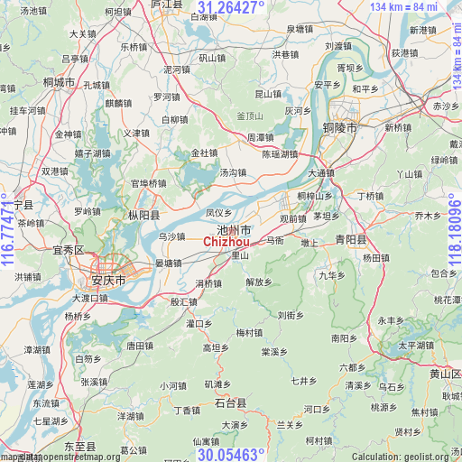
Chizhou GPS coordinates[2]
30° 39' 40.824" North, 117° 28' 40.188" East
| Map corner | latitude | longitude |
|---|---|---|
| Upper-left | 31.26427°, | 116.77471° |
| Center: | 30.66134°, | 117.47783° |
| Lower-right: | 30.05463°, | 118.18096° |
| Map W x H: | 134.5×134.5 km | = 83.6×83.6mi |
| max Lat: | 53.31946° ⇑48.2% North |
| Chizhou: | 30.66134° |
| min Lat: | ⇓51.8% South 18.22056° |
| min Long | Chizhou | max Long |
| 75.07348° | 117.47783° | 134.28917° |
| W 68.7%⇐ | ⇒31.3% E |
Elevation
Elevation of Chizhou is 21 m = 69 ft, and this is 463.8 m = 1522 ft below average elevation for this country.
| Max E: |
5622 m = 18445 ft | 82.4% |
| Avg. | 484.8 m = 1591 ft | |
| Chizhou | 21 m = 69 ft | |
Min E: |
-3 m = -10 ft | 17.6% |
See also: Chizhou elevation on elevation.city.
Geographical zone
Chizhou is located in North temperate zone (between Tropic of Cancer and the Arctic Circle). Distance of this Northern Tropic circle is 803.3 km =499.1 mi to South.| Distance of | km | miles | from Chizhou |
|---|---|---|---|
| North Pole | 6597.8 | 4099.7 | to North |
| Arctic Circle | 3992 | 2480.5 | to North |
| Tropic Cancer | 803.3 | 499.1 | to South |
| Equator | 3409.2 | 2118.4 | to South |


Nearby cities:
15 places around Chizhou: (largest is in red/bold)
• Anqing
44.4 km =27.6 mi,  248°
248°
• Gaohe
61.4 km =38.2 mi,  278°
278°
• Hewan
60.2 km =37.4 mi,  73°
73°
• Hou’an
56.3 km =35 mi,  102°
102°
• Qiaomu
57.5 km =35.7 mi,  85°
85°
• Qili
51.4 km =31.9 mi,  179°
179°
• Rongcheng
34.2 km =21.3 mi, 93°
• Wusong
43.4 km =27 mi,  42°
42°
• Xinfeng
60 km =37.3 mi,  106°
106°
• Xinhua
58.8 km =36.5 mi, 113°
• Yashan
54.3 km =33.7 mi, 71°
• Yijin
39.3 km =24.4 mi,  317°
317°
• Youhua
50.6 km =31.4 mi, 87°
• Zhuyang
50.7 km =31.5 mi,  81°
81°
• Zongyang
26.5 km =16.5 mi, 279°
Sources, notices
• [Note1] Compared only with cities in China existing in our database
• [Src1] Map data: © OpenStreetMap contributors (CC-BY-SA)
• [Src2] Other city data from geonames.org with taken over terms of usage.
• [Src3] Geographical zone / Annual Mean Temperature by Robert A. Rohde @ Wikipedia
