Gaohe geodata
Gaohe (Anhui) is a seat of a third-order administrative division; located in China in Asia/Shanghai (GMT+8) time zone. In our database, there are 1268 cities with bigger population. Compared to other cities in China, 52.5% of cities are located further ↓South; 65.2% of cities are located further ←West and 83.9% of cities have higher elevation than Gaohe. Note1


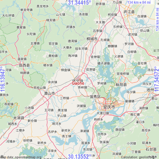
Gaohe GPS coordinates[2]
30° 44' 30.228" North, 116° 50' 33.324" East
| Map corner | latitude | longitude |
|---|---|---|
| Upper-left | 31.34415°, | 116.13947° |
| Center: | 30.74173°, | 116.84259° |
| Lower-right: | 30.13552°, | 117.54572° |
| Map W x H: | 134.4×134.4 km | = 83.5×83.5mi |
| max Lat: | 53.31946° ⇑47.5% North |
| Gaohe: | 30.74173° |
| min Lat: | ⇓52.5% South 18.22056° |
| min Long | Gaohe | max Long |
| 75.07348° | 116.84259° | 134.28917° |
| W 65.2%⇐ | ⇒34.8% E |
Elevation
Elevation of Gaohe is 18 m = 59 ft, and this is 466.8 m = 1531 ft below average elevation for this country.
| Max E: |
5622 m = 18445 ft | 83.9% |
| Avg. | 484.8 m = 1591 ft | |
| Gaohe | 18 m = 59 ft | |
Min E: |
-3 m = -10 ft | 16.1% |
See also: China elevation on elevation.city.
Geographical zone
Gaohe is located in North temperate zone (between Tropic of Cancer and the Arctic Circle). Distance of this Northern Tropic circle is 812.2 km =504.7 mi to South.| Distance of | km | miles | from Gaohe |
|---|---|---|---|
| North Pole | 6588.9 | 4094.2 | to North |
| Arctic Circle | 3983 | 2474.9 | to North |
| Tropic Cancer | 812.2 | 504.7 | to South |
| Equator | 3418.2 | 2124 | to South |


Nearby cities:
15 places around Gaohe: (largest is in red/bold)
• Anqing
32 km =19.9 mi,  142°
142°
• Chizhou
61.4 km =38.2 mi,  98°
98°
• Jinxi
62.9 km =39.1 mi,  236°
236°
• Leiyang
70.8 km =44 mi,  192°
192°
• Lucheng
68.8 km =42.8 mi,  37°
37°
• Madang
85.4 km =53.1 mi, 192°
• Meicheng
27.8 km =17.3 mi, 244°
• Qili
85.7 km =53.3 mi,  134°
134°
• Quedian
62.4 km =38.8 mi,  359°
359°
• Shucheng Chengguanzhen
82.1 km =51 mi,  7°
7°
• Tiantang
48.6 km =30.2 mi,  284°
284°
• Tongcheng
35.4 km =22 mi,  20°
20°
• Yaodu
73.3 km =45.5 mi,  166°
166°
• Yijin
39.2 km =24.4 mi,  59°
59°
• Zongyang
34.9 km =21.7 mi, 97°
Sources, notices
• [Note1] Compared only with cities in China existing in our database
• [Src1] Map data: © OpenStreetMap contributors (CC-BY-SA)
• [Src2] Other city data from geonames.org with taken over terms of usage.
• [Src3] Geographical zone / Annual Mean Temperature by Robert A. Rohde @ Wikipedia
