Zongyang geodata
Zongyang (Anhui) is a seat of a third-order administrative division; located in China in Asia/Shanghai (GMT+8) time zone. In our database, there are 1268 cities with bigger population. Compared to other cities in China, 52% of cities are located further ↓South; 67.2% of cities are located further ←West and 75.3% of cities have higher elevation than Zongyang. Note1


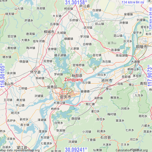
Zongyang GPS coordinates[2]
30° 41' 56.004" North, 117° 12' 15.012" East
| Map corner | latitude | longitude |
|---|---|---|
| Upper-left | 31.30158°, | 116.50105° |
| Center: | 30.69889°, | 117.20417° |
| Lower-right: | 30.09241°, | 117.9073° |
| Map W x H: | 134.4×134.4 km | = 83.5×83.5mi |
| max Lat: | 53.31946° ⇑48% North |
| Zongyang: | 30.69889° |
| min Lat: | ⇓52% South 18.22056° |
| min Long | Zongyang | max Long |
| 75.07348° | 117.20417° | 134.28917° |
| W 67.2%⇐ | ⇒32.8% E |
Elevation
Elevation of Zongyang is 36 m = 118 ft, and this is 448.8 m = 1472 ft below average elevation for this country.
| Max E: |
5622 m = 18445 ft | 75.3% |
| Avg. | 484.8 m = 1591 ft | |
| Zongyang | 36 m = 118 ft | |
Min E: |
-3 m = -10 ft | 24.7% |
See also: China elevation on elevation.city.
Geographical zone
Zongyang is located in North temperate zone (between Tropic of Cancer and the Arctic Circle). Distance of this Northern Tropic circle is 807.5 km =501.8 mi to South.| Distance of | km | miles | from Zongyang |
|---|---|---|---|
| North Pole | 6593.7 | 4097.1 | to North |
| Arctic Circle | 3987.8 | 2477.9 | to North |
| Tropic Cancer | 807.5 | 501.8 | to South |
| Equator | 3413.4 | 2121 | to South |


Nearby cities:
15 places around Zongyang: (largest is in red/bold)
• Anqing
25.5 km =15.8 mi,  216°
216°
• Chizhou
26.5 km =16.5 mi,  99°
99°
• Gaohe
34.9 km =21.7 mi,  277°
277°
• Lucheng
59.9 km =37.2 mi,  6°
6°
• Meicheng
60.1 km =37.3 mi,  263°
263°
• Qili
61.5 km =38.2 mi,  154°
154°
• Quedian
75.6 km =47 mi,  332°
332°
• Rongcheng
60.7 km =37.7 mi, 95°
• Tongcheng
43.8 km =27.2 mi, 329°
• Wusong
61.9 km =38.5 mi,  63°
63°
• Yaodu
69 km =42.9 mi,  195°
195°
• Yashan
78.7 km =48.9 mi,  80°
80°
• Yijin
24.6 km =15.3 mi,  358°
358°
• Youhua
76.8 km =47.7 mi,  91°
91°
• Zhuyang
76.4 km =47.5 mi, 87°
Sources, notices
• [Note1] Compared only with cities in China existing in our database
• [Src1] Map data: © OpenStreetMap contributors (CC-BY-SA)
• [Src2] Other city data from geonames.org with taken over terms of usage.
• [Src3] Geographical zone / Annual Mean Temperature by Robert A. Rohde @ Wikipedia
