Yijin geodata
Yijin (Anhui) is a seat of a fourth-order administrative division; located in China in Asia/Shanghai (GMT+8) time zone. In our database, there are 1268 cities with bigger population. Compared to other cities in China, 54.1% of cities are located further ↓South; 67.1% of cities are located further ←West and 78.8% of cities have higher elevation than Yijin. Note1


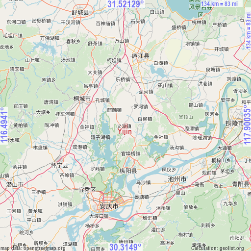
Yijin GPS coordinates[2]
30° 55' 12" North, 117° 11' 49.992" East
| Map corner | latitude | longitude |
|---|---|---|
| Upper-left | 31.52129°, | 116.4941° |
| Center: | 30.92°, | 117.19722° |
| Lower-right: | 30.3149°, | 117.90035° |
| Map W x H: | 134.1×134.1 km | = 83.3×83.3mi |
| max Lat: | 53.31946° ⇑45.9% North |
| Yijin: | 30.92° |
| min Lat: | ⇓54.1% South 18.22056° |
| min Long | Yijin | max Long |
| 75.07348° | 117.19722° | 134.28917° |
| W 67.1%⇐ | ⇒32.9% E |
Elevation
Elevation of Yijin is 29 m = 95 ft, and this is 455.8 m = 1495 ft below average elevation for this country.
| Max E: |
5622 m = 18445 ft | 78.8% |
| Avg. | 484.8 m = 1591 ft | |
| Yijin | 29 m = 95 ft | |
Min E: |
-3 m = -10 ft | 21.2% |
See also: China elevation on elevation.city.
Geographical zone
Yijin is located in North temperate zone (between Tropic of Cancer and the Arctic Circle). Distance of this Northern Tropic circle is 832.1 km =517 mi to South.| Distance of | km | miles | from Yijin |
|---|---|---|---|
| North Pole | 6569.1 | 4081.8 | to North |
| Arctic Circle | 3963.2 | 2462.6 | to North |
| Tropic Cancer | 832.1 | 517 | to South |
| Equator | 3438 | 2136.3 | to South |


Nearby cities:
15 places around Yijin: (largest is in red/bold)
• Anqing
47.4 km =29.5 mi,  197°
197°
• Chizhou
39.3 km =24.4 mi,  137°
137°
• Digang
80.5 km =50 mi,  73°
73°
• Gaohe
39.2 km =24.4 mi,  239°
239°
• Lucheng
35.8 km =22.2 mi,  12°
12°
• Meicheng
67 km =41.6 mi, 241°
• Quedian
54.5 km =33.9 mi,  321°
321°
• Rongcheng
68.3 km =42.4 mi,  116°
116°
• Shucheng Chengguanzhen
65.9 km =40.9 mi,  339°
339°
• Tongcheng
25.1 km =15.6 mi,  301°
301°
• Wucheng
78.3 km =48.7 mi,  58°
58°
• Wusong
56 km =34.8 mi,  86°
86°
• Yashan
79 km =49.1 mi,  98°
98°
• Zhuyang
79.7 km =49.5 mi,  105°
105°
• Zongyang
24.6 km =15.3 mi,  178°
178°
Sources, notices
• [Note1] Compared only with cities in China existing in our database
• [Src1] Map data: © OpenStreetMap contributors (CC-BY-SA)
• [Src2] Other city data from geonames.org with taken over terms of usage.
• [Src3] Geographical zone / Annual Mean Temperature by Robert A. Rohde @ Wikipedia
