Chibi geodata
Chibi (Hubei) is a seat of a fourth-order administrative division; located in China in Asia/Shanghai (GMT+8) time zone. In our database, there are 1268 cities with bigger population. Compared to other cities in China, 55.3% of cities are located further ↑North; 53.5% of cities are located further →East and 76.7% of cities have higher elevation than Chibi. Note1


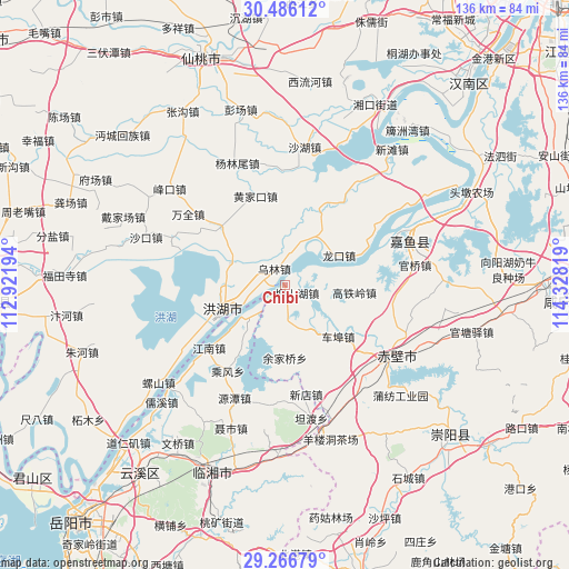
Chibi GPS coordinates[2]
29° 52' 41.952" North, 113° 37' 30.216" East
| Map corner | latitude | longitude |
|---|---|---|
| Upper-left | 30.48612°, | 112.92194° |
| Center: | 29.87832°, | 113.62506° |
| Lower-right: | 29.26679°, | 114.32819° |
| Map W x H: | 135.6×135.6 km | = 84.3×84.3mi |
| max Lat: | 53.31946° ⇑55.3% North |
| Chibi: | 29.87832° |
| min Lat: | ⇓44.7% South 18.22056° |
| min Long | Chibi | max Long |
| 75.07348° | 113.62506° | 134.28917° |
| W 46.5%⇐ | ⇒53.5% E |
Elevation
Elevation of Chibi is 33 m = 108 ft, and this is 451.8 m = 1482 ft below average elevation for this country.
| Max E: |
5622 m = 18445 ft | 76.7% |
| Avg. | 484.8 m = 1591 ft | |
| Chibi | 33 m = 108 ft | |
Min E: |
-3 m = -10 ft | 23.3% |
See also: China elevation on elevation.city.
Geographical zone
Chibi is located in North temperate zone (between Tropic of Cancer and the Arctic Circle). Distance of this Northern Tropic circle is 716.2 km =445 mi to South.| Distance of | km | miles | from Chibi |
|---|---|---|---|
| North Pole | 6684.9 | 4153.8 | to North |
| Arctic Circle | 4079 | 2534.6 | to North |
| Tropic Cancer | 716.2 | 445 | to South |
| Equator | 3322.2 | 2064.3 | to South |


Nearby cities:
15 places around Chibi: (largest is in red/bold)
• Chahe
20.3 km =12.6 mi,  311°
311°
• Cha’anling
31.8 km =19.8 mi,  150°
150°
• Chebu
17.9 km =11.1 mi,  132°
132°
• Gaotieling
16.3 km =10.1 mi,  96°
96°
• Guanqiao
30.9 km =19.2 mi,  80°
80°
• Huangjiakou
22.4 km =13.9 mi,  341°
341°
• Liushanhu
2.8 km =1.7 mi, 129°
• Longkou
14.7 km =9.1 mi,  61°
61°
• Luxi
6.8 km =4.2 mi,  50°
50°
• Puqi
30.7 km =19.1 mi, 125°
• Wanquan
28.5 km =17.7 mi, 306°
• Wulin
4.8 km =3 mi,  323°
323°
• Xindi
16.7 km =10.4 mi,  245°
245°
• Xindian
26.3 km =16.3 mi,  168°
168°
• Yanglinwei
30.6 km =19 mi, 338°
Sources, notices
• [Note1] Compared only with cities in China existing in our database
• [Src1] Map data: © OpenStreetMap contributors (CC-BY-SA)
• [Src2] Other city data from geonames.org with taken over terms of usage.
• [Src3] Geographical zone / Annual Mean Temperature by Robert A. Rohde @ Wikipedia
