Gaotieling geodata
Gaotieling (Hubei) is a seat of a fourth-order administrative division; located in China in Asia/Shanghai (GMT+8) time zone. In our database, there are 1268 cities with bigger population. Compared to other cities in China, 55.6% of cities are located further ↑North; 52.6% of cities are located further →East and 74.4% of cities have higher elevation than Gaotieling. Note1


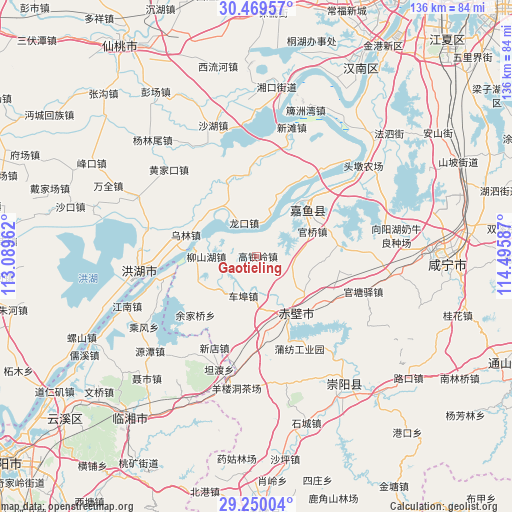
Gaotieling GPS coordinates[2]
29° 51' 42.012" North, 113° 47' 33.864" East
| Map corner | latitude | longitude |
|---|---|---|
| Upper-left | 30.46957°, | 113.08962° |
| Center: | 29.86167°, | 113.79274° |
| Lower-right: | 29.25004°, | 114.49587° |
| Map W x H: | 135.6×135.6 km | = 84.3×84.3mi |
| max Lat: | 53.31946° ⇑55.6% North |
| Gaotieling: | 29.86167° |
| min Lat: | ⇓44.4% South 18.22056° |
| min Long | Gaotieling | max Long |
| 75.07348° | 113.79274° | 134.28917° |
| W 47.4%⇐ | ⇒52.6% E |
Elevation
Elevation of Gaotieling is 38 m = 125 ft, and this is 446.8 m = 1466 ft below average elevation for this country.
| Max E: |
5622 m = 18445 ft | 74.4% |
| Avg. | 484.8 m = 1591 ft | |
| Gaotieling | 38 m = 125 ft | |
Min E: |
-3 m = -10 ft | 25.6% |
See also: China elevation on elevation.city.
Geographical zone
Gaotieling is located in North temperate zone (between Tropic of Cancer and the Arctic Circle). Distance of this Northern Tropic circle is 714.4 km =443.9 mi to South.| Distance of | km | miles | from Gaotieling |
|---|---|---|---|
| North Pole | 6686.8 | 4155 | to North |
| Arctic Circle | 4080.9 | 2535.8 | to North |
| Tropic Cancer | 714.4 | 443.9 | to South |
| Equator | 3320.3 | 2063.1 | to South |


Nearby cities:
15 places around Gaotieling: (largest is in red/bold)
• Cha’anling
25.8 km =16 mi,  181°
181°
• Chebu
10.8 km =6.7 mi,  196°
196°
• Chibi
16.3 km =10.1 mi,  276°
276°
• Guanqiao
15.9 km =9.9 mi,  64°
64°
• Guantangyi
29.9 km =18.6 mi,  108°
108°
• Liushanhu
14 km =8.7 mi,  270°
270°
• Longkou
9.4 km =5.8 mi,  339°
339°
• Luxi
12.6 km =7.8 mi,  299°
299°
• Puqi
18.3 km =11.4 mi,  151°
151°
• Shenshan
22.8 km =14.2 mi,  79°
79°
• Wulin
19.9 km =12.4 mi,  286°
286°
• Xindian
26.4 km =16.4 mi, 204°
• Xinjie
25.5 km =15.8 mi,  48°
48°
• Yuyue
23.9 km =14.9 mi,  43°
43°
• Zhonghuopu
23 km =14.3 mi,  119°
119°
Sources, notices
• [Note1] Compared only with cities in China existing in our database
• [Src1] Map data: © OpenStreetMap contributors (CC-BY-SA)
• [Src2] Other city data from geonames.org with taken over terms of usage.
• [Src3] Geographical zone / Annual Mean Temperature by Robert A. Rohde @ Wikipedia
