Sixi geodata
Sixi (Jiangxi) is a seat of a fourth-order administrative division; located in China in Asia/Shanghai (GMT+8) time zone. In our database, there are 1268 cities with bigger population. Compared to other cities in China, 71.3% of cities are located further ↑North; 54.8% of cities are located further ←West and 72.3% of cities have higher elevation than Sixi. Note1


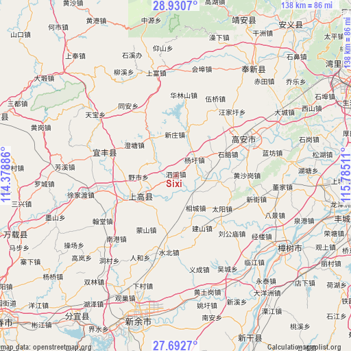
Sixi GPS coordinates[2]
28° 18' 48.6" North, 115° 4' 55.128" East
| Map corner | latitude | longitude |
|---|---|---|
| Upper-left | 28.9307°, | 114.37886° |
| Center: | 28.3135°, | 115.08198° |
| Lower-right: | 27.6927°, | 115.78511° |
| Map W x H: | 137.7×137.7 km | = 85.6×85.6mi |
| max Lat: | 53.31946° ⇑71.3% North |
| Sixi: | 28.3135° |
| min Lat: | ⇓28.7% South 18.22056° |
| min Long | Sixi | max Long |
| 75.07348° | 115.08198° | 134.28917° |
| W 54.8%⇐ | ⇒45.2% E |
Elevation
Elevation of Sixi is 44 m = 144 ft, and this is 440.8 m = 1446 ft below average elevation for this country.
| Max E: |
5622 m = 18445 ft | 72.3% |
| Avg. | 484.8 m = 1591 ft | |
| Sixi | 44 m = 144 ft | |
Min E: |
-3 m = -10 ft | 27.7% |
See also: China elevation on elevation.city.
Geographical zone
Sixi is located in North temperate zone (between Tropic of Cancer and the Arctic Circle). Distance of this Northern Tropic circle is 542.2 km =336.9 mi to South.| Distance of | km | miles | from Sixi |
|---|---|---|---|
| North Pole | 6858.9 | 4261.9 | to North |
| Arctic Circle | 4253 | 2642.7 | to North |
| Tropic Cancer | 542.2 | 336.9 | to South |
| Equator | 3148.2 | 1956.2 | to South |


Nearby cities:
15 places around Sixi: (largest is in red/bold)
• Aoshan
11.6 km =7.2 mi,  240°
240°
• Aoyang
17.8 km =11.1 mi, 242°
• Chengtang
20.4 km =12.7 mi,  306°
306°
• Cunqian
18 km =11.2 mi,  15°
15°
• Huibu
16.8 km =10.4 mi,  97°
97°
• Jinjiang
19.9 km =12.4 mi, 243°
• Longtan
17.6 km =10.9 mi,  59°
59°
• Shangganshan
16.2 km =10.1 mi,  222°
222°
• Tangpu
17.3 km =10.7 mi,  326°
326°
• Taxia
16.5 km =10.3 mi,  231°
231°
• Xiangcheng
14.9 km =9.3 mi,  148°
148°
• Xinjiebu
10 km =6.2 mi,  193°
193°
• Xinzhuang
16.1 km =10 mi,  359°
359°
• Yangxu
9.7 km =6 mi,  50°
50°
• Yeshi
14.5 km =9 mi,  268°
268°
Sources, notices
• [Note1] Compared only with cities in China existing in our database
• [Src1] Map data: © OpenStreetMap contributors (CC-BY-SA)
• [Src2] Other city data from geonames.org with taken over terms of usage.
• [Src3] Geographical zone / Annual Mean Temperature by Robert A. Rohde @ Wikipedia
