Aoyang geodata
Aoyang (Jiangxi) is a seat of a third-order administrative division; located in China in Asia/Shanghai (GMT+8) time zone. In our database, there are 1268 cities with bigger population. Compared to other cities in China, 72% of cities are located further ↑North; 53.8% of cities are located further ←West and 69.5% of cities have higher elevation than Aoyang. Note1


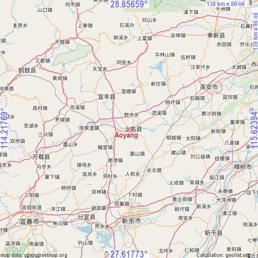
Aoyang GPS coordinates[2]
28° 14' 20.256" North, 114° 55' 14.916" East
| Map corner | latitude | longitude |
|---|---|---|
| Upper-left | 28.85659°, | 114.21769° |
| Center: | 28.23896°, | 114.92081° |
| Lower-right: | 27.61773°, | 115.62394° |
| Map W x H: | 137.7×137.7 km | = 85.6×85.6mi |
| max Lat: | 53.31946° ⇑72% North |
| Aoyang: | 28.23896° |
| min Lat: | ⇓28% South 18.22056° |
| min Long | Aoyang | max Long |
| 75.07348° | 114.92081° | 134.28917° |
| W 53.8%⇐ | ⇒46.2% E |
Elevation
Elevation of Aoyang is 54 m = 177 ft, and this is 430.8 m = 1413 ft below average elevation for this country.
| Max E: |
5622 m = 18445 ft | 69.5% |
| Avg. | 484.8 m = 1591 ft | |
| Aoyang | 54 m = 177 ft | |
Min E: |
-3 m = -10 ft | 30.5% |
See also: China elevation on elevation.city.
Geographical zone
Aoyang is located in North temperate zone (between Tropic of Cancer and the Arctic Circle). Distance of this Northern Tropic circle is 534 km =331.8 mi to South.| Distance of | km | miles | from Aoyang |
|---|---|---|---|
| North Pole | 6867.2 | 4267.1 | to North |
| Arctic Circle | 4261.3 | 2647.8 | to North |
| Tropic Cancer | 534 | 331.8 | to South |
| Equator | 3139.9 | 1951 | to South |


Nearby cities:
15 places around Aoyang: (largest is in red/bold)
• Aoshan
6.2 km =3.9 mi,  65°
65°
• Chengtang
20.5 km =12.7 mi,  358°
358°
• Damiao
18.4 km =11.4 mi,  191°
191°
• Hantang
16 km =9.9 mi,  233°
233°
• Hushan
20.7 km =12.9 mi,  156°
156°
• Jinjiang
2.1 km =1.3 mi,  250°
250°
• Luzhou
8.9 km =5.5 mi, 246°
• Mengshan
13.5 km =8.4 mi, 162°
• Nangang
18.3 km =11.4 mi,  204°
204°
• Shangganshan
6 km =3.7 mi,  126°
126°
• Shishi
14.8 km =9.2 mi,  278°
278°
• Sixi
17.8 km =11.1 mi,  62°
62°
• Taxia
3.6 km =2.2 mi, 125°
• Xinjiebu
13.5 km =8.4 mi,  96°
96°
• Yeshi
7.9 km =4.9 mi,  9°
9°
Sources, notices
• [Note1] Compared only with cities in China existing in our database
• [Src1] Map data: © OpenStreetMap contributors (CC-BY-SA)
• [Src2] Other city data from geonames.org with taken over terms of usage.
• [Src3] Geographical zone / Annual Mean Temperature by Robert A. Rohde @ Wikipedia
