Chenghe geodata
Chenghe (Hubei) is a seat of a fourth-order administrative division; located in China in Asia/Shanghai (GMT+8) time zone. In our database, there are 1268 cities with bigger population. Compared to other cities in China, 62.9% of cities are located further ↓South; 60.4% of cities are located further →East and 63.3% of cities have higher elevation than Chenghe. Note1


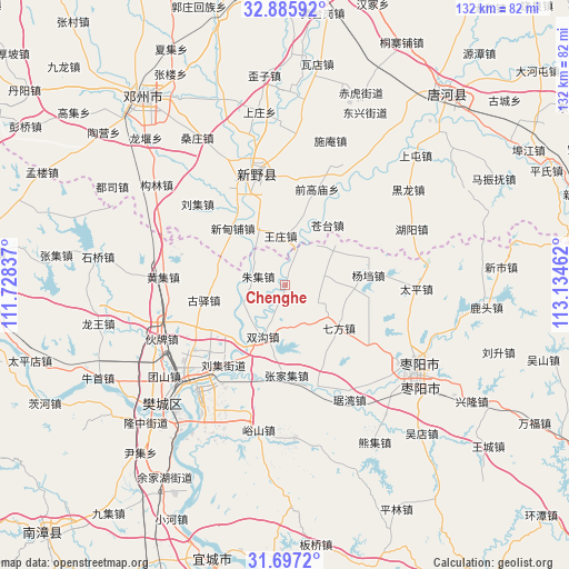
Chenghe GPS coordinates[2]
32° 17' 36.636" North, 112° 25' 53.364" East
| Map corner | latitude | longitude |
|---|---|---|
| Upper-left | 32.88592°, | 111.72837° |
| Center: | 32.29351°, | 112.43149° |
| Lower-right: | 31.6972°, | 113.13462° |
| Map W x H: | 132.2×132.2 km | = 82.1×82.1mi |
| max Lat: | 53.31946° ⇑37.1% North |
| Chenghe: | 32.29351° |
| min Lat: | ⇓62.9% South 18.22056° |
| min Long | Chenghe | max Long |
| 75.07348° | 112.43149° | 134.28917° |
| W 39.6%⇐ | ⇒60.4% E |
Elevation
Elevation of Chenghe is 81 m = 266 ft, and this is 403.8 m = 1325 ft below average elevation for this country.
| Max E: |
5622 m = 18445 ft | 63.3% |
| Avg. | 484.8 m = 1591 ft | |
| Chenghe | 81 m = 266 ft | |
Min E: |
-3 m = -10 ft | 36.7% |
See also: China elevation on elevation.city.
Geographical zone
Chenghe is located in North temperate zone (between Tropic of Cancer and the Arctic Circle). Distance of this Northern Tropic circle is 984.8 km =611.9 mi to South.| Distance of | km | miles | from Chenghe |
|---|---|---|---|
| North Pole | 6416.4 | 3987 | to North |
| Arctic Circle | 3810.5 | 2367.7 | to North |
| Tropic Cancer | 984.8 | 611.9 | to South |
| Equator | 3590.7 | 2231.2 | to South |


Nearby cities:
15 places around Chenghe: (largest is in red/bold)
• Dongxiang
19.8 km =12.3 mi,  165°
165°
• Guyi
19.3 km =12 mi,  259°
259°
• Hancheng
26.1 km =16.2 mi,  343°
343°
• Huangji
28.2 km =17.5 mi,  274°
274°
• Huopai
32.1 km =19.9 mi,  243°
243°
• Juwan
30.8 km =19.1 mi,  150°
150°
• Mizhuang
31.4 km =19.5 mi, 235°
• Qifang
15.9 km =9.9 mi,  128°
128°
• Shuanggou
12.5 km =7.8 mi,  202°
202°
• Taiping
30.6 km =19 mi,  91°
91°
• Tuanshan
35.1 km =21.8 mi,  232°
232°
• Yangdang
19.4 km =12.1 mi,  83°
83°
• Yushan
34.3 km =21.3 mi,  190°
190°
• Zhangjiaji
21.1 km =13.1 mi,  178°
178°
• Zhangwan
34.2 km =21.3 mi, 226°
Sources, notices
• [Note1] Compared only with cities in China existing in our database
• [Src1] Map data: © OpenStreetMap contributors (CC-BY-SA)
• [Src2] Other city data from geonames.org with taken over terms of usage.
• [Src3] Geographical zone / Annual Mean Temperature by Robert A. Rohde @ Wikipedia
