Chaohu geodata
Chaohu (Anhui) is a populated place; located in China in Asia/Shanghai (GMT+8) time zone. With population of 138,463 people, there are 319 cities with bigger population in this country. Compared to other cities in China, 59% of cities are located further ↓South; 70.1% of cities are located further ←West and 88.7% of cities have higher elevation than Chaohu. Note1


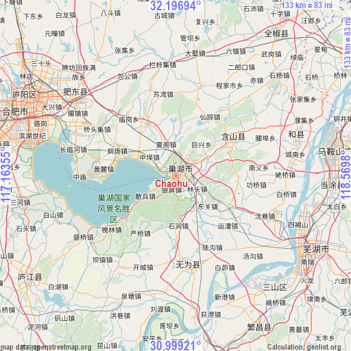
Chaohu GPS coordinates[2]
31° 36' 0" North, 117° 52' 0.012" East
| Map corner | latitude | longitude |
|---|---|---|
| Upper-left | 32.19694°, | 117.16355° |
| Center: | 31.6°, | 117.86667° |
| Lower-right: | 30.99921°, | 118.5698° |
| Map W x H: | 133.2×133.2 km | = 82.8×82.8mi |
| max Lat: | 53.31946° ⇑41% North |
| Chaohu: | 31.6° |
| min Lat: | ⇓59% South 18.22056° |
| min Long | Chaohu | max Long |
| 75.07348° | 117.86667° | 134.28917° |
| W 70.1%⇐ | ⇒29.9% E |
Elevation
Elevation of Chaohu is 11 m = 36 ft, and this is 473.8 m = 1554 ft below average elevation for this country.
| Max E: |
5622 m = 18445 ft | 88.7% |
| Avg. | 484.8 m = 1591 ft | |
| Chaohu | 11 m = 36 ft | |
Min E: |
-3 m = -10 ft | 11.3% |
See also: Chaohu elevation on elevation.city.
Geographical zone
Chaohu is located in North temperate zone (between Tropic of Cancer and the Arctic Circle). Distance of this Northern Tropic circle is 907.7 km =564 mi to South.| Distance of | km | miles | from Chaohu |
|---|---|---|---|
| North Pole | 6493.5 | 4034.9 | to North |
| Arctic Circle | 3887.6 | 2415.6 | to North |
| Tropic Cancer | 907.7 | 564 | to South |
| Equator | 3513.6 | 2183.2 | to South |


Nearby cities:
15 places around Chaohu: (largest is in red/bold)
• Baiqiao
42.4 km =26.3 mi,  99°
99°
• Chengjia
40.2 km =25 mi,  30°
30°
• Dougou
30.3 km =18.8 mi,  152°
152°
• Gongqiao
30.2 km =18.8 mi, 96°
• Huanfeng
25.6 km =15.9 mi,  59°
59°
• Laoqiao
41.2 km =25.6 mi,  88°
88°
• Lianhe
42.7 km =26.5 mi,  84°
84°
• Shanhou
41 km =25.5 mi,  41°
41°
• Taochang
24.2 km =15 mi, 90°
• Tongzha
28.3 km =17.6 mi,  116°
116°
• Wucheng
35.3 km =21.9 mi,  174°
174°
• Xianzong
26.1 km =16.2 mi, 30°
• Xiaojiangba
39.6 km =24.6 mi, 152°
• Xiexiang
30.2 km =18.8 mi, 34°
• Yuncao
27.8 km =17.3 mi,  135°
135°
Sources, notices
• [Note1] Compared only with cities in China existing in our database
• [Src1] Map data: © OpenStreetMap contributors (CC-BY-SA)
• [Src2] Other city data from geonames.org with taken over terms of usage.
• [Src3] Geographical zone / Annual Mean Temperature by Robert A. Rohde @ Wikipedia
