Changzhi geodata
Changzhi (Shanxi) is a populated place; located in China in Asia/Shanghai (GMT+8) time zone. With population of 699,514 people, there are 88 cities with bigger population in this country. Compared to other cities in China, 75.5% of cities are located further ↓South; 63.8% of cities are located further →East and 68.3% of cities have lower elevation than Changzhi. Note1


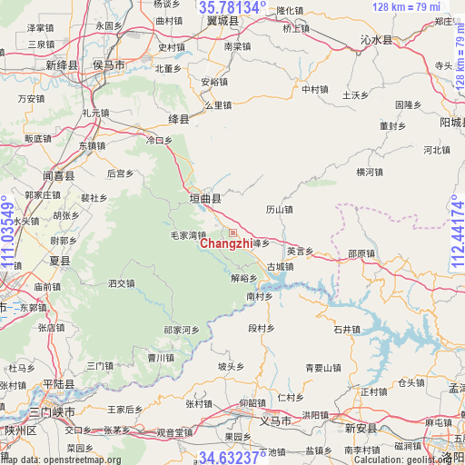
Changzhi GPS coordinates[2]
35° 12' 32.004" North, 111° 44' 18.996" East
| Map corner | latitude | longitude |
|---|---|---|
| Upper-left | 35.78134°, | 111.03549° |
| Center: | 35.20889°, | 111.73861° |
| Lower-right: | 34.63237°, | 112.44174° |
| Map W x H: | 127.8×127.8 km | = 79.4×79.4mi |
| max Lat: | 53.31946° ⇑24.5% North |
| Changzhi: | 35.20889° |
| min Lat: | ⇓75.5% South 18.22056° |
| min Long | Changzhi | max Long |
| 75.07348° | 111.73861° | 134.28917° |
| W 36.2%⇐ | ⇒63.8% E |
Elevation
Elevation of Changzhi is 381 m = 1250 ft, and this is 103.8 m = 341 ft below average elevation for this country.
| Max E: |
5622 m = 18445 ft | 31.7% |
| Avg. | 484.8 m = 1591 ft | |
| Changzhi | 381 m = 1250 ft | |
Min E: |
-3 m = -10 ft | 68.3% |
See also: Changzhi elevation on elevation.city.
Geographical zone
Changzhi is located in North temperate zone (between Tropic of Cancer and the Arctic Circle). Distance of this Northern Tropic circle is 1308.9 km =813.3 mi to South.| Distance of | km | miles | from Changzhi |
|---|---|---|---|
| North Pole | 6092.2 | 3785.5 | to North |
| Arctic Circle | 3486.3 | 2166.3 | to North |
| Tropic Cancer | 1308.9 | 813.3 | to South |
| Equator | 3914.9 | 2432.6 | to South |


Nearby cities:
15 places around Changzhi: (largest is in red/bold)
• Beidong
48.6 km =30.2 mi,  338°
338°
• Gujiang
35.9 km =22.3 mi,  332°
332°
• Guojiazhuang
53.4 km =33.2 mi,  281°
281°
• Hedi
37.3 km =23.2 mi,  291°
291°
• Houcun
42.1 km =26.2 mi,  303°
303°
• Hougong
35 km =21.7 mi, 298°
• Liyuan
50.2 km =31.2 mi,  311°
311°
• Mianchi Chengguanzhen
50.6 km =31.4 mi,  177°
177°
• Nanjie
46 km =28.6 mi, 301°
• Peishe
39.4 km =24.5 mi, 284°
• Qianqiu
53.3 km =33.1 mi,  166°
166°
• Shimen
18.6 km =11.6 mi, 286°
• Tongcheng
50.1 km =31.1 mi, 288°
• Xincheng
12.2 km =7.6 mi, 326°
• Yaofeng
48.5 km =30.1 mi,  260°
260°
Sources, notices
• [Note1] Compared only with cities in China existing in our database
• [Src1] Map data: © OpenStreetMap contributors (CC-BY-SA)
• [Src2] Other city data from geonames.org with taken over terms of usage.
• [Src3] Geographical zone / Annual Mean Temperature by Robert A. Rohde @ Wikipedia
