Changsha geodata
Changsha (Jiangsu) is a seat of a fourth-order administrative division; located in China in Asia/Shanghai (GMT+8) time zone. In our database, there are 1268 cities with bigger population. Compared to other cities in China, 63.6% of cities are located further ↓South; 89.1% of cities are located further ←West and 91.2% of cities have higher elevation than Changsha. Note1


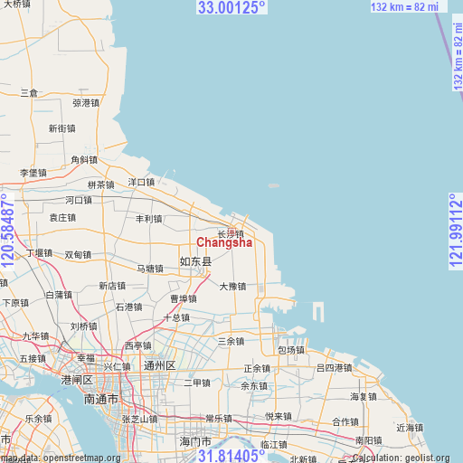
Changsha GPS coordinates[2]
32° 24' 34.56" North, 121° 17' 16.764" East
| Map corner | latitude | longitude |
|---|---|---|
| Upper-left | 33.00125°, | 120.58487° |
| Center: | 32.4096°, | 121.28799° |
| Lower-right: | 31.81405°, | 121.99112° |
| Map W x H: | 132×132 km | = 82×82mi |
| max Lat: | 53.31946° ⇑36.4% North |
| Changsha: | 32.4096° |
| min Lat: | ⇓63.6% South 18.22056° |
| min Long | Changsha | max Long |
| 75.07348° | 121.28799° | 134.28917° |
| W 89.1%⇐ | ⇒10.9% E |
Elevation
Elevation of Changsha is 9 m = 30 ft, and this is 475.8 m = 1561 ft below average elevation for this country.
| Max E: |
5622 m = 18445 ft | 91.2% |
| Avg. | 484.8 m = 1591 ft | |
| Changsha | 9 m = 30 ft | |
Min E: |
-3 m = -10 ft | 8.8% |
See also: China elevation on elevation.city.
Geographical zone
Changsha is located in North temperate zone (between Tropic of Cancer and the Arctic Circle). Distance of this Northern Tropic circle is 997.7 km =619.9 mi to South.| Distance of | km | miles | from Changsha |
|---|---|---|---|
| North Pole | 6403.5 | 3978.9 | to North |
| Arctic Circle | 3797.6 | 2359.7 | to North |
| Tropic Cancer | 997.7 | 619.9 | to South |
| Equator | 3603.6 | 2239.2 | to South |


Nearby cities:
15 places around Changsha: (largest is in red/bold)
• Bingfang
15.6 km =9.7 mi,  177°
177°
• Caobu
25.9 km =16.1 mi,  226°
226°
• Dayu
11 km =6.8 mi, 175°
• Fengli
23.3 km =14.5 mi,  280°
280°
• Haifeng
28.6 km =17.8 mi,  161°
161°
• Juegang
14.1 km =8.8 mi,  223°
223°
• Juzhen
8.7 km =5.4 mi,  273°
273°
• Matang
25.5 km =15.8 mi,  247°
247°
• Qi’an
34.2 km =21.3 mi, 221°
• Sanyu
31.1 km =19.3 mi, 180°
• Shizong
28.7 km =17.8 mi,  212°
212°
• Wujia
30.5 km =19 mi,  195°
195°
• Xiamazhuang
34.7 km =21.6 mi,  293°
293°
• Xujia Changzhuang
19.8 km =12.3 mi, 277°
• Zhangjiayuan
19 km =11.8 mi, 285°
Sources, notices
• [Note1] Compared only with cities in China existing in our database
• [Src1] Map data: © OpenStreetMap contributors (CC-BY-SA)
• [Src2] Other city data from geonames.org with taken over terms of usage.
• [Src3] Geographical zone / Annual Mean Temperature by Robert A. Rohde @ Wikipedia
