Fengli geodata
Fengli (Jiangsu) is a seat of a fourth-order administrative division; located in China in Asia/Shanghai (GMT+8) time zone. In our database, there are 1268 cities with bigger population. Compared to other cities in China, 63.8% of cities are located further ↓South; 88% of cities are located further ←West and 97.2% of cities have higher elevation than Fengli. Note1


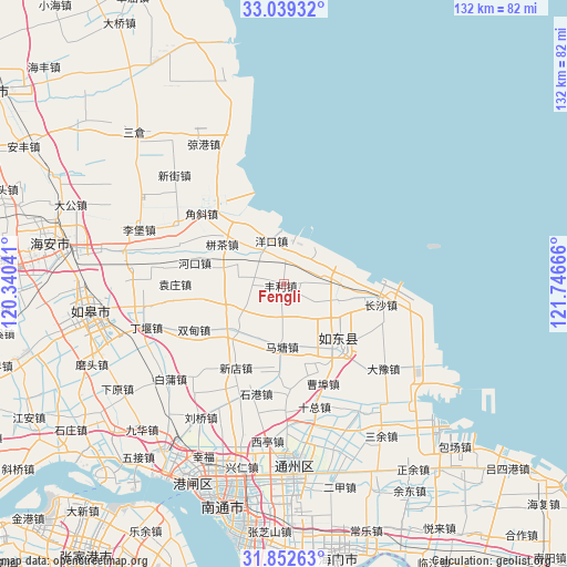
Fengli GPS coordinates[2]
32° 26' 52.548" North, 121° 2' 36.708" East
| Map corner | latitude | longitude |
|---|---|---|
| Upper-left | 33.03932°, | 120.34041° |
| Center: | 32.44793°, | 121.04353° |
| Lower-right: | 31.85263°, | 121.74666° |
| Map W x H: | 131.9×131.9 km | = 82×82mi |
| max Lat: | 53.31946° ⇑36.2% North |
| Fengli: | 32.44793° |
| min Lat: | ⇓63.8% South 18.22056° |
| min Long | Fengli | max Long |
| 75.07348° | 121.04353° | 134.28917° |
| W 88%⇐ | ⇒12% E |
Elevation
Elevation of Fengli is 5 m = 16 ft, and this is 479.8 m = 1574 ft below average elevation for this country.
| Max E: |
5622 m = 18445 ft | 97.2% |
| Avg. | 484.8 m = 1591 ft | |
| Fengli | 5 m = 16 ft | |
Min E: |
-3 m = -10 ft | 2.8% |
See also: China elevation on elevation.city.
Geographical zone
Fengli is located in North temperate zone (between Tropic of Cancer and the Arctic Circle). Distance of this Northern Tropic circle is 1002 km =622.6 mi to South.| Distance of | km | miles | from Fengli |
|---|---|---|---|
| North Pole | 6399.2 | 3976.3 | to North |
| Arctic Circle | 3793.3 | 2357 | to North |
| Tropic Cancer | 1002 | 622.6 | to South |
| Equator | 3607.9 | 2241.8 | to South |


Nearby cities:
15 places around Fengli: (largest is in red/bold)
• Bingcha
16.5 km =10.3 mi,  300°
300°
• Caobu
22.5 km =14 mi,  169°
169°
• Chahe
15.7 km =9.8 mi,  227°
227°
• Changsha
23.3 km =14.5 mi,  100°
100°
• Hekou
21.3 km =13.2 mi,  283°
283°
• Juegang
19.7 km =12.2 mi,  137°
137°
• Juzhen
14.7 km =9.1 mi, 104°
• Matang
14.2 km =8.8 mi,  182°
182°
• Shigang
26.3 km =16.3 mi,  194°
194°
• Shuangdian
23.5 km =14.6 mi,  242°
242°
• Xiamazhuang
12.9 km =8 mi,  316°
316°
• Xindian
22.6 km =14 mi,  209°
209°
• Xujia Changzhuang
3.8 km =2.4 mi,  118°
118°
• Yuanzhuang
25.4 km =15.8 mi,  270°
270°
• Zhangjiayuan
4.6 km =2.9 mi,  81°
81°
Sources, notices
• [Note1] Compared only with cities in China existing in our database
• [Src1] Map data: © OpenStreetMap contributors (CC-BY-SA)
• [Src2] Other city data from geonames.org with taken over terms of usage.
• [Src3] Geographical zone / Annual Mean Temperature by Robert A. Rohde @ Wikipedia
