Changluo geodata
Changluo (Jiangxi) is a seat of a fourth-order administrative division; located in China in Asia/Shanghai (GMT+8) time zone. In our database, there are 1268 cities with bigger population. Compared to other cities in China, 83.1% of cities are located further ↑North; 55.3% of cities are located further ←West and 58.5% of cities have lower elevation than Changluo. Note1


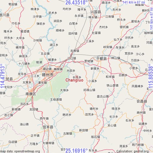
Changluo GPS coordinates[2]
25° 48' 13.896" North, 115° 10' 56.1" East
| Map corner | latitude | longitude |
|---|---|---|
| Upper-left | 26.43518°, | 114.47913° |
| Center: | 25.80386°, | 115.18225° |
| Lower-right: | 25.16916°, | 115.88538° |
| Map W x H: | 140.8×140.8 km | = 87.5×87.5mi |
| max Lat: | 53.31946° ⇑83.1% North |
| Changluo: | 25.80386° |
| min Lat: | ⇓16.9% South 18.22056° |
| min Long | Changluo | max Long |
| 75.07348° | 115.18225° | 134.28917° |
| W 55.3%⇐ | ⇒44.7% E |
Elevation
Elevation of Changluo is 241 m = 791 ft, and this is 243.8 m = 800 ft below average elevation for this country.
| Max E: |
5622 m = 18445 ft | 41.5% |
| Avg. | 484.8 m = 1591 ft | |
| Changluo | 241 m = 791 ft | |
Min E: |
-3 m = -10 ft | 58.5% |
See also: China elevation on elevation.city.
Geographical zone
Changluo is located in North temperate zone (between Tropic of Cancer and the Arctic Circle). Distance of this Northern Tropic circle is 263.2 km =163.5 mi to South.| Distance of | km | miles | from Changluo |
|---|---|---|---|
| North Pole | 7137.9 | 4435.3 | to North |
| Arctic Circle | 4532.1 | 2816.1 | to North |
| Tropic Cancer | 263.2 | 163.5 | to South |
| Equator | 2869.1 | 1782.8 | to South |


Nearby cities:
15 places around Changluo: (largest is in red/bold)
• Dabu
16.7 km =10.4 mi,  222°
222°
• Datian
7.9 km =4.9 mi,  316°
316°
• Ganzhou
25.4 km =15.8 mi,  280°
280°
• Gongjiang
28.5 km =17.7 mi,  53°
53°
• Jiangkou
17.7 km =11 mi,  343°
343°
• Jibu
24.3 km =15.1 mi,  354°
354°
• Licun
21.6 km =13.4 mi,  77°
77°
• Luojiang
11 km =6.8 mi,  39°
39°
• Luo’ao
18.3 km =11.4 mi, 37°
• Maodian
17.8 km =11.1 mi,  309°
309°
• Meilin
18.8 km =11.7 mi,  294°
294°
• Qilushan
16.7 km =10.4 mi,  135°
135°
• Wangmudu
28.4 km =17.6 mi, 220°
• Xiaoxi
15.2 km =9.4 mi,  104°
104°
• Xinbei
18.3 km =11.4 mi,  64°
64°
Sources, notices
• [Note1] Compared only with cities in China existing in our database
• [Src1] Map data: © OpenStreetMap contributors (CC-BY-SA)
• [Src2] Other city data from geonames.org with taken over terms of usage.
• [Src3] Geographical zone / Annual Mean Temperature by Robert A. Rohde @ Wikipedia
