Qilushan geodata
Qilushan (Jiangxi) is a seat of a fourth-order administrative division; located in China in Asia/Shanghai (GMT+8) time zone. In our database, there are 1268 cities with bigger population. Compared to other cities in China, 83.5% of cities are located further ↑North; 55.8% of cities are located further ←West and 55.2% of cities have lower elevation than Qilushan. Note1


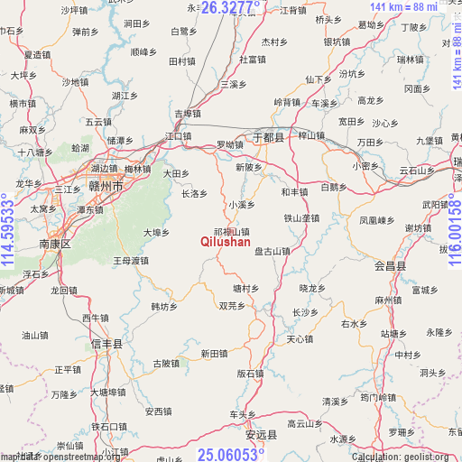
Qilushan GPS coordinates[2]
25° 41' 44.88" North, 115° 17' 54.42" East
| Map corner | latitude | longitude |
|---|---|---|
| Upper-left | 26.3277°, | 114.59533° |
| Center: | 25.6958°, | 115.29845° |
| Lower-right: | 25.06053°, | 116.00158° |
| Map W x H: | 140.9×140.9 km | = 87.6×87.6mi |
| max Lat: | 53.31946° ⇑83.5% North |
| Qilushan: | 25.6958° |
| min Lat: | ⇓16.5% South 18.22056° |
| min Long | Qilushan | max Long |
| 75.07348° | 115.29845° | 134.28917° |
| W 55.8%⇐ | ⇒44.2% E |
Elevation
Elevation of Qilushan is 208 m = 682 ft, and this is 276.8 m = 908 ft below average elevation for this country.
| Max E: |
5622 m = 18445 ft | 44.8% |
| Avg. | 484.8 m = 1591 ft | |
| Qilushan | 208 m = 682 ft | |
Min E: |
-3 m = -10 ft | 55.2% |
See also: China elevation on elevation.city.
Geographical zone
Qilushan is located in North temperate zone (between Tropic of Cancer and the Arctic Circle). Distance of this Northern Tropic circle is 251.2 km =156.1 mi to South.| Distance of | km | miles | from Qilushan |
|---|---|---|---|
| North Pole | 7150 | 4442.8 | to North |
| Arctic Circle | 4544.1 | 2823.6 | to North |
| Tropic Cancer | 251.2 | 156.1 | to South |
| Equator | 2857.1 | 1775.3 | to South |


Nearby cities:
15 places around Qilushan: (largest is in red/bold)
• Changluo
16.7 km =10.4 mi,  315°
315°
• Dabu
22.9 km =14.2 mi,  269°
269°
• Datian
24.7 km =15.3 mi, 316°
• Fucha
21.8 km =13.5 mi,  142°
142°
• Hefeng
22.3 km =13.9 mi,  58°
58°
• Jingshi
20.1 km =12.5 mi,  98°
98°
• Licun
19.3 km =12 mi,  29°
29°
• Longbu
25.9 km =16.1 mi,  162°
162°
• Luojiang
21 km =13 mi,  347°
347°
• Pangushan
13.7 km =8.5 mi,  115°
115°
• Shuangyuan
22.5 km =14 mi,  179°
179°
• Tangcun
17.8 km =11.1 mi,  165°
165°
• Tieshanlong
21.7 km =13.5 mi,  78°
78°
• Xiaoxi
8.9 km =5.5 mi,  20°
20°
• Xinbei
20.4 km =12.7 mi,  13°
13°
Sources, notices
• [Note1] Compared only with cities in China existing in our database
• [Src1] Map data: © OpenStreetMap contributors (CC-BY-SA)
• [Src2] Other city data from geonames.org with taken over terms of usage.
• [Src3] Geographical zone / Annual Mean Temperature by Robert A. Rohde @ Wikipedia
