Luojiang geodata
Luojiang (Jiangxi) is a seat of a fourth-order administrative division; located in China in Asia/Shanghai (GMT+8) time zone. In our database, there are 1268 cities with bigger population. Compared to other cities in China, 82.9% of cities are located further ↑North; 55.6% of cities are located further ←West and 55.6% of cities have higher elevation than Luojiang. Note1


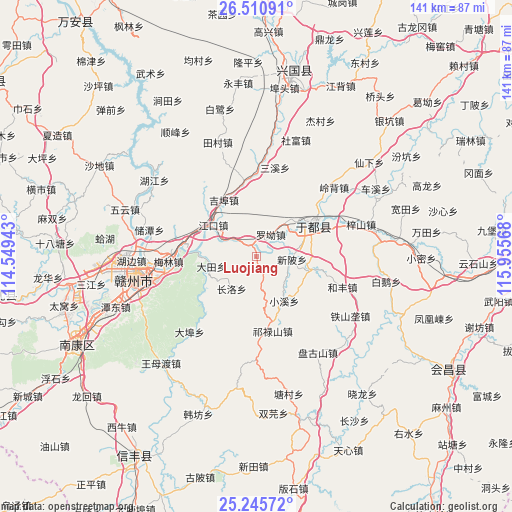
Luojiang GPS coordinates[2]
25° 52' 48.036" North, 115° 15' 9.18" East
| Map corner | latitude | longitude |
|---|---|---|
| Upper-left | 26.51091°, | 114.54943° |
| Center: | 25.88001°, | 115.25255° |
| Lower-right: | 25.24572°, | 115.95568° |
| Map W x H: | 140.7×140.7 km | = 87.4×87.4mi |
| max Lat: | 53.31946° ⇑82.9% North |
| Luojiang: | 25.88001° |
| min Lat: | ⇓17.1% South 18.22056° |
| min Long | Luojiang | max Long |
| 75.07348° | 115.25255° | 134.28917° |
| W 55.6%⇐ | ⇒44.4% E |
Elevation
Elevation of Luojiang is 127 m = 417 ft, and this is 357.8 m = 1174 ft below average elevation for this country.
| Max E: |
5622 m = 18445 ft | 55.6% |
| Avg. | 484.8 m = 1591 ft | |
| Luojiang | 127 m = 417 ft | |
Min E: |
-3 m = -10 ft | 44.4% |
See also: China elevation on elevation.city.
Geographical zone
Luojiang is located in North temperate zone (between Tropic of Cancer and the Arctic Circle). Distance of this Northern Tropic circle is 271.7 km =168.8 mi to South.| Distance of | km | miles | from Luojiang |
|---|---|---|---|
| North Pole | 7129.5 | 4430.1 | to North |
| Arctic Circle | 4523.6 | 2810.8 | to North |
| Tropic Cancer | 271.7 | 168.8 | to South |
| Equator | 2877.6 | 1788.1 | to South |


Nearby cities:
15 places around Luojiang: (largest is in red/bold)
• Changluo
11 km =6.8 mi,  219°
219°
• Dabu
27.7 km =17.2 mi, 221°
• Datian
12.8 km =8 mi,  257°
257°
• Gongjiang
17.9 km =11.1 mi,  61°
61°
• Hefeng
25.2 km =15.7 mi,  110°
110°
• Jiangkou
14.7 km =9.1 mi,  305°
305°
• Jibu
18.4 km =11.4 mi,  328°
328°
• Licun
14.5 km =9 mi,  104°
104°
• Luo’ao
7.3 km =4.5 mi,  33°
33°
• Maodian
21 km =13 mi,  277°
277°
• Meilin
24.2 km =15 mi,  268°
268°
• Qilushan
21 km =13 mi,  167°
167°
• Sanxixiang
25 km =15.5 mi,  10°
10°
• Xiaoxi
14.4 km =8.9 mi,  147°
147°
• Xinbei
9.5 km =5.9 mi,  94°
94°
Sources, notices
• [Note1] Compared only with cities in China existing in our database
• [Src1] Map data: © OpenStreetMap contributors (CC-BY-SA)
• [Src2] Other city data from geonames.org with taken over terms of usage.
• [Src3] Geographical zone / Annual Mean Temperature by Robert A. Rohde @ Wikipedia
