Wulongshan geodata
Wulongshan (Chongqing) is a seat of a fourth-order administrative division; located in China in Asia/Shanghai (GMT+8) time zone. In our database, there are 1268 cities with bigger population. Compared to other cities in China, 59.4% of cities are located further ↑North; 82% of cities are located further →East and 85.3% of cities have lower elevation than Wulongshan. Note1


Wulongshan GPS coordinates[2]
29° 31' 49.368" North, 107° 33' 34.812" East
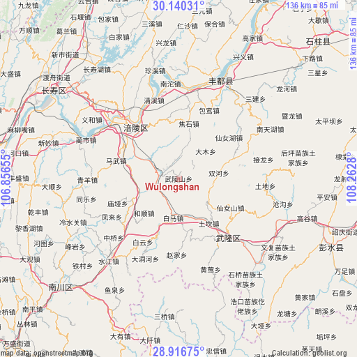
| Map corner | latitude | longitude |
|---|---|---|
| Upper-left | 30.14031°, | 106.85655° |
| Center: | 29.53038°, | 107.55967° |
| Lower-right: | 28.91675°, | 108.2628° |
| Map W x H: | 136×136 km | = 84.5×84.5mi |
| max Lat: | 53.31946° ⇑59.4% North |
| Wulongshan: | 29.53038° |
| min Lat: | ⇓40.6% South 18.22056° |
| min Long | Wulongshan | max Long |
| 75.07348° | 107.55967° | 134.28917° |
| W 18%⇐ | ⇒82% E |
Elevation
Elevation of Wulongshan is 1001 m = 3284 ft, and this is 516.2 m = 1694 ft above average elevation for this country.
| Max E: |
5622 m = 18445 ft | 14.7% |
| Wulongshan | 1001 m 3284 ft | |
| Avg. | 484.8 m = 1591 ft | |
Min E: |
-3 m = -10 ft | 85.3% |
See also: China elevation on elevation.city.
Geographical zone
Wulongshan is located in North temperate zone (between Tropic of Cancer and the Arctic Circle). Distance of this Northern Tropic circle is 677.6 km =421 mi to South.| Distance of | km | miles | from Wulongshan |
|---|---|---|---|
| North Pole | 6723.6 | 4177.9 | to North |
| Arctic Circle | 4117.7 | 2558.6 | to North |
| Tropic Cancer | 677.6 | 421 | to South |
| Equator | 3283.5 | 2040.3 | to South |


Nearby cities:
15 places around Wulongshan: (largest is in red/bold)
• Baima
14.3 km =8.9 mi,  189°
189°
• Baitao
7.4 km =4.6 mi,  287°
287°
• Changba
23.3 km =14.5 mi,  200°
200°
• Damu
14 km =8.7 mi,  45°
45°
• Heshun
18.6 km =11.6 mi,  225°
225°
• Jiaoshi
21 km =13 mi,  10°
10°
• Jiudian
24.7 km =15.3 mi,  300°
300°
• Mawu
24.8 km =15.4 mi, 286°
• Shanwo
9 km =5.6 mi,  4°
4°
• Shuanghe
15.5 km =9.6 mi,  82°
82°
• Taihe
23.7 km =14.7 mi,  268°
268°
• Tiantai
17.1 km =10.6 mi,  323°
323°
• Yajiang
19.9 km =12.4 mi,  244°
244°
• Yangjiao
15.4 km =9.6 mi,  162°
162°
• Zili
18.7 km =11.6 mi,  282°
282°
Sources, notices
• [Note1] Compared only with cities in China existing in our database
• [Src1] Map data: © OpenStreetMap contributors (CC-BY-SA)
• [Src2] Other city data from geonames.org with taken over terms of usage.
• [Src3] Geographical zone / Annual Mean Temperature by Robert A. Rohde @ Wikipedia
