Yangjiao geodata
Yangjiao (Chongqing) is a seat of a fourth-order administrative division; located in China in Asia/Shanghai (GMT+8) time zone. In our database, there are 1268 cities with bigger population. Compared to other cities in China, 60.8% of cities are located further ↑North; 81.8% of cities are located further →East and 55.3% of cities have lower elevation than Yangjiao. Note1


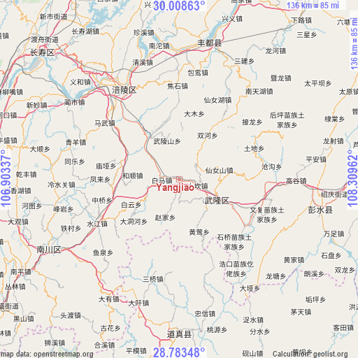
Yangjiao GPS coordinates[2]
29° 23' 52.44" North, 107° 36' 23.364" East
| Map corner | latitude | longitude |
|---|---|---|
| Upper-left | 30.00863°, | 106.90337° |
| Center: | 29.3979°, | 107.60649° |
| Lower-right: | 28.78348°, | 108.30962° |
| Map W x H: | 136.2×136.2 km | = 84.6×84.6mi |
| max Lat: | 53.31946° ⇑60.8% North |
| Yangjiao: | 29.3979° |
| min Lat: | ⇓39.2% South 18.22056° |
| min Long | Yangjiao | max Long |
| 75.07348° | 107.60649° | 134.28917° |
| W 18.2%⇐ | ⇒81.8% E |
Elevation
Elevation of Yangjiao is 209 m = 686 ft, and this is 275.8 m = 905 ft below average elevation for this country.
| Max E: |
5622 m = 18445 ft | 44.7% |
| Avg. | 484.8 m = 1591 ft | |
| Yangjiao | 209 m = 686 ft | |
Min E: |
-3 m = -10 ft | 55.3% |
See also: China elevation on elevation.city.
Geographical zone
Yangjiao is located in North temperate zone (between Tropic of Cancer and the Arctic Circle). Distance of this Northern Tropic circle is 662.8 km =411.8 mi to South.| Distance of | km | miles | from Yangjiao |
|---|---|---|---|
| North Pole | 6738.3 | 4187 | to North |
| Arctic Circle | 4132.4 | 2567.8 | to North |
| Tropic Cancer | 662.8 | 411.8 | to South |
| Equator | 3268.7 | 2031.1 | to South |


Nearby cities:
15 places around Yangjiao: (largest is in red/bold)
• Baima
7 km =4.3 mi,  275°
275°
• Baitao
20.6 km =12.8 mi,  325°
325°
• Baiyun
20.5 km =12.7 mi,  242°
242°
• Changba
14.6 km =9.1 mi, 241°
• Damu
25.2 km =15.7 mi,  12°
12°
• Heshun
17.8 km =11.1 mi, 275°
• Huangying
21.8 km =13.5 mi,  159°
159°
• Huolu
25.8 km =16 mi,  90°
90°
• Shanwo
23.9 km =14.9 mi,  350°
350°
• Shuanghe
20 km =12.4 mi,  32°
32°
• Tiekuang
24 km =14.9 mi,  222°
222°
• Wulongshan
15.4 km =9.6 mi,  342°
342°
• Xiangkou
14.7 km =9.1 mi,  120°
120°
• Yajiang
23.4 km =14.5 mi,  285°
285°
• Zhaojia
15.7 km =9.8 mi,  200°
200°
Sources, notices
• [Note1] Compared only with cities in China existing in our database
• [Src1] Map data: © OpenStreetMap contributors (CC-BY-SA)
• [Src2] Other city data from geonames.org with taken over terms of usage.
• [Src3] Geographical zone / Annual Mean Temperature by Robert A. Rohde @ Wikipedia
